You are here: Home > Network List > CI - Caltech Regional Seismic Network Stations List
> Station GLA Glamis, California, USA > Earthquake Result Viewer
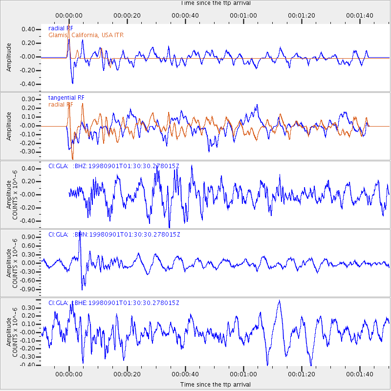
GLA Glamis, California, USA - Earthquake Result Viewer
*The percent match for this event was below the threshold and hence no stack was calculated.
| Earthquake location: |
Tonga Islands |
| Earthquake latitude/longitude: |
-17.6/-174.8 |
| Earthquake time(UTC): |
1998/09/01 (244) 01:19:37 GMT |
| Earthquake Depth: |
220 km |
| Earthquake Magnitude: |
5.6 UNKNOWN, 5.3 MB, 5.6 MW |
| Earthquake Catalog/Contributor: |
WHDF/NEIC |
|
| Network: |
CI Caltech Regional Seismic Network |
| Station: |
GLA Glamis, California, USA |
| Lat/Lon: |
33.05 N/114.83 W |
| Elevation: |
627 m |
|
| Distance: |
76.2 deg |
| Az: |
48.463 deg |
| Baz: |
238.242 deg |
| Ray Param: |
$rayparam |
*The percent match for this event was below the threshold and hence was not used in the summary stack. |
|
| Radial Match: |
64.609276 % |
| Radial Bump: |
400 |
| Transverse Match: |
57.629745 % |
| Transverse Bump: |
400 |
| SOD ConfigId: |
4480 |
| Insert Time: |
2010-02-25 23:38:15.320 +0000 |
| GWidth: |
2.5 |
| Max Bumps: |
400 |
| Tol: |
0.001 |
|
Signal To Noise
| Channel | StoN | STA | LTA |
| CI:GLA: :BHN:19980901T01:30:30.278015Z | 4.8721933 | 4.3025767E-7 | 8.830882E-8 |
| CI:GLA: :BHE:19980901T01:30:30.278015Z | 2.1463568 | 1.9723363E-7 | 9.189228E-8 |
| CI:GLA: :BHZ:19980901T01:30:30.278015Z | 1.8141795 | 2.5672986E-7 | 1.4151293E-7 |
| Arrivals |
| Ps | |
| PpPs | |
| PsPs/PpSs | |


