You are here: Home > Network List > IU - Global Seismograph Network (GSN - IRIS/USGS) Stations List
> Station KONO Kongsberg, Norway > Earthquake Result Viewer
KONO Kongsberg, Norway - Earthquake Result Viewer
| Earthquake location: |
Mindanao, Philippines |
| Earthquake latitude/longitude: |
7.2/126.6 |
| Earthquake time(UTC): |
1993/05/11 (131) 18:26:48 GMT |
| Earthquake Depth: |
33 km |
| Earthquake Magnitude: |
6.1 MB, 6.6 MS, 6.5 UNKNOWN |
| Earthquake Catalog/Contributor: |
WHDF/NEIC |
|
| Network: |
IU Global Seismograph Network (GSN - IRIS/USGS) |
| Station: |
KONO Kongsberg, Norway |
| Lat/Lon: |
59.65 N/9.60 E |
| Elevation: |
216 m |
|
| Distance: |
97.0 deg |
| Az: |
332.887 deg |
| Baz: |
62.923 deg |
| Ray Param: |
0.040342458 |
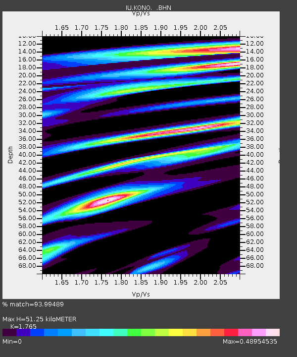
| Estimated Moho Depth: |
51.25 km |
| Estimated Crust Vp/Vs: |
1.76 |
| Assumed Crust Vp: |
6.545 km/s |
| Estimated Crust Vs: |
3.708 km/s |
| Estimated Crust Poisson's Ratio: |
0.26 |
|
| Radial Match: |
93.99489 % |
| Radial Bump: |
400 |
| Transverse Match: |
79.34817 % |
| Transverse Bump: |
400 |
| SOD ConfigId: |
16938 |
| Insert Time: |
2010-03-04 15:53:40.552 +0000 |
| GWidth: |
2.5 |
| Max Bumps: |
400 |
| Tol: |
0.001 |
|
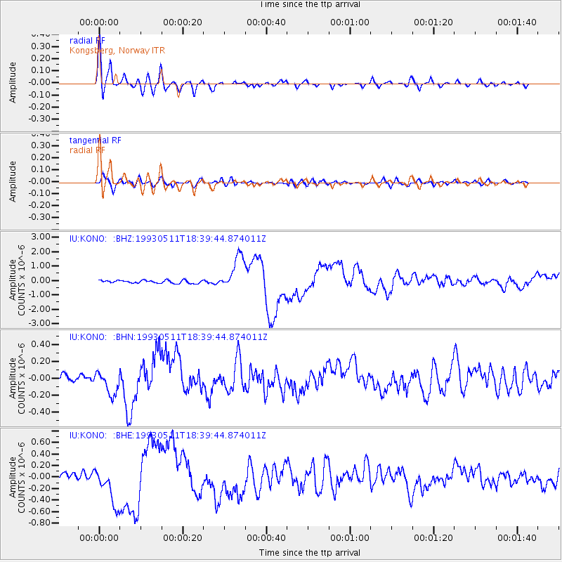
Signal To Noise
| Channel | StoN | STA | LTA |
| IU:KONO: :BHN:19930511T18:39:44.874011Z | 3.0503283 | 1.4160278E-7 | 4.6422148E-8 |
| IU:KONO: :BHE:19930511T18:39:44.874011Z | 5.692529 | 3.4216143E-7 | 6.0107105E-8 |
| IU:KONO: :BHZ:19930511T18:39:44.874011Z | 11.890693 | 1.2319057E-6 | 1.03602524E-7 |
| Arrivals |
| Ps | 6.1 SECOND |
| PpPs | 21 SECOND |
| PsPs/PpSs | 27 SECOND |


