You are here: Home > Network List > UW - Pacific Northwest Regional Seismic Network Stations List
> Station MRBL Marblemount, WA, USA > Earthquake Result Viewer
MRBL Marblemount, WA, USA - Earthquake Result Viewer
| Earthquake location: |
Mariana Islands Region |
| Earthquake latitude/longitude: |
21.9/146.6 |
| Earthquake time(UTC): |
2015/08/17 (229) 14:42:32 GMT |
| Earthquake Depth: |
3.1 km |
| Earthquake Magnitude: |
5.6 MWB |
| Earthquake Catalog/Contributor: |
NEIC PDE/NEIC COMCAT |
|
| Network: |
UW Pacific Northwest Regional Seismic Network |
| Station: |
MRBL Marblemount, WA, USA |
| Lat/Lon: |
48.52 N/121.48 W |
| Elevation: |
75 m |
|
| Distance: |
75.1 deg |
| Az: |
43.445 deg |
| Baz: |
286.196 deg |
| Ray Param: |
0.051908206 |
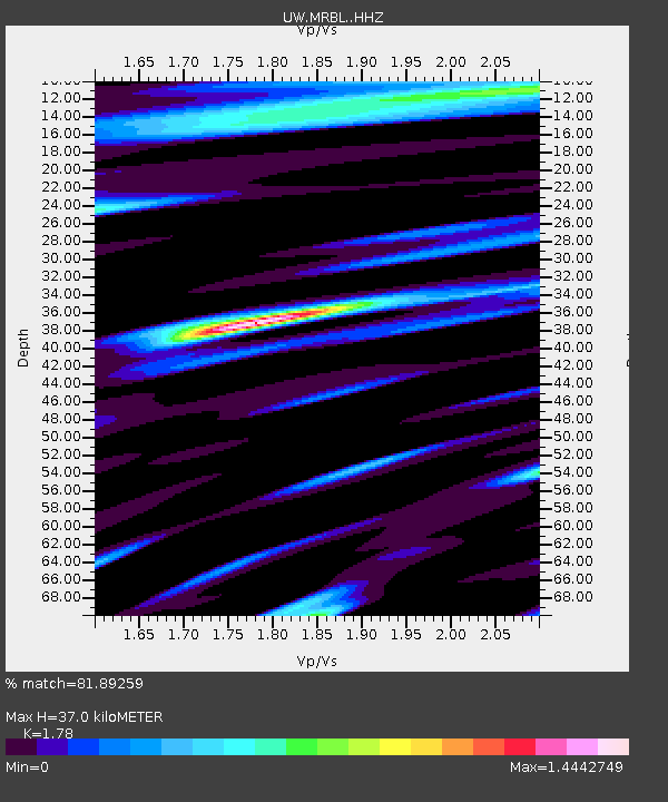
| Estimated Moho Depth: |
37.0 km |
| Estimated Crust Vp/Vs: |
1.78 |
| Assumed Crust Vp: |
6.566 km/s |
| Estimated Crust Vs: |
3.689 km/s |
| Estimated Crust Poisson's Ratio: |
0.27 |
|
| Radial Match: |
81.89259 % |
| Radial Bump: |
400 |
| Transverse Match: |
76.076836 % |
| Transverse Bump: |
400 |
| SOD ConfigId: |
7422571 |
| Insert Time: |
2019-04-20 12:10:39.425 +0000 |
| GWidth: |
2.5 |
| Max Bumps: |
400 |
| Tol: |
0.001 |
|
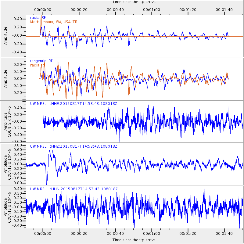
Signal To Noise
| Channel | StoN | STA | LTA |
| UW:MRBL: :HHZ:20150817T14:53:43.108018Z | 7.232991 | 3.735521E-7 | 5.1645593E-8 |
| UW:MRBL: :HHN:20150817T14:53:43.108018Z | 1.5301976 | 1.0802541E-7 | 7.0595725E-8 |
| UW:MRBL: :HHE:20150817T14:53:43.108018Z | 1.5630696 | 1.2647203E-7 | 8.0912606E-8 |
| Arrivals |
| Ps | 4.5 SECOND |
| PpPs | 15 SECOND |
| PsPs/PpSs | 20 SECOND |


