You are here: Home > Network List > CI - Caltech Regional Seismic Network Stations List
> Station GLA Glamis, California, USA > Earthquake Result Viewer
GLA Glamis, California, USA - Earthquake Result Viewer
*The percent match for this event was below the threshold and hence no stack was calculated.
| Earthquake location: |
Mariana Islands |
| Earthquake latitude/longitude: |
13.3/144.0 |
| Earthquake time(UTC): |
1998/09/08 (251) 09:10:03 GMT |
| Earthquake Depth: |
141 km |
| Earthquake Magnitude: |
5.8 MB, 5.8 UNKNOWN, 5.8 MW |
| Earthquake Catalog/Contributor: |
WHDF/NEIC |
|
| Network: |
CI Caltech Regional Seismic Network |
| Station: |
GLA Glamis, California, USA |
| Lat/Lon: |
33.05 N/114.83 W |
| Elevation: |
627 m |
|
| Distance: |
92.0 deg |
| Az: |
55.532 deg |
| Baz: |
287.092 deg |
| Ray Param: |
$rayparam |
*The percent match for this event was below the threshold and hence was not used in the summary stack. |
|
| Radial Match: |
75.10424 % |
| Radial Bump: |
400 |
| Transverse Match: |
70.30652 % |
| Transverse Bump: |
400 |
| SOD ConfigId: |
4480 |
| Insert Time: |
2010-02-25 23:38:22.802 +0000 |
| GWidth: |
2.5 |
| Max Bumps: |
400 |
| Tol: |
0.001 |
|
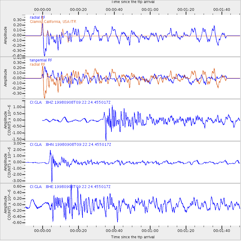
Signal To Noise
| Channel | StoN | STA | LTA |
| CI:GLA: :BHN:19980908T09:22:24.455017Z | 6.396505 | 6.115455E-7 | 9.56062E-8 |
| CI:GLA: :BHE:19980908T09:22:24.455017Z | 0.8469691 | 6.702968E-8 | 7.914065E-8 |
| CI:GLA: :BHZ:19980908T09:22:24.455017Z | 2.0969207 | 1.7877403E-7 | 8.525551E-8 |
| Arrivals |
| Ps | |
| PpPs | |
| PsPs/PpSs | |


