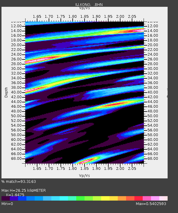
KONO Kongsberg, Norway - Earthquake Result Viewer

Earthquake location: Myanmar-China Border Region
Earthquake latitude/longitude: 21.9/99.2
Earthquake time(UTC): 1995/07/11 (192) 21:46:39 GMT
Earthquake Depth: 13 km
Earthquake Magnitude: 6.1 MB, 7.2 MS, 6.9 UNKNOWN, 6.8 MW
Earthquake Catalog/Contributor: WHDF/NEIC
Network: IU Global Seismograph Network (GSN - IRIS/USGS)
Station: KONO Kongsberg, Norway
Lat/Lon: 59.65 N/9.60 E
Elevation: 216 m
Distance: 71.1 deg
Az: 327.543 deg
Baz: 78.88 deg
Ray Param: 0.05452161
Estimated Moho Depth: 26.25 km
Estimated Crust Vp/Vs: 1.65
Assumed Crust Vp: 6.545 km/s
Estimated Crust Vs: 3.973 km/s
Estimated Crust Poisson's Ratio: 0.21
Radial Match: 93.3163 %
Radial Bump: 375
Transverse Match: 80.6821 %
Transverse Bump: 400
SOD ConfigId: 6273
Insert Time: 2010-03-04 15:55:09.687 +0000
GWidth: 2.5
Max Bumps: 400
Tol: 0.001

Signal To Noise

ChannelStoNSTALTA
IU:KONO: :BHN:19950711T21:57:26.525012Z0.50476582.9149192E-85.7747954E-8
IU:KONO: :BHE:19950711T21:57:26.525012Z1.24004539.028341E-87.2806536E-8
IU:KONO: :BHZ:19950711T21:57:26.525012Z2.62281782.0890397E-77.9648686E-8
Arrivals
Ps2.7 SECOND
PpPs10 SECOND
PsPs/PpSs13 SECOND