You are here: Home > Network List > NI - North-East Italy Broadband Network Stations List
> Station FUSE Fusea > Earthquake Result Viewer
FUSE Fusea - Earthquake Result Viewer
| Earthquake location: |
Eastern Gulf Of Aden |
| Earthquake latitude/longitude: |
13.7/51.8 |
| Earthquake time(UTC): |
2015/08/17 (229) 16:16:59 GMT |
| Earthquake Depth: |
10 km |
| Earthquake Magnitude: |
5.7 MWB |
| Earthquake Catalog/Contributor: |
NEIC PDE/NEIC COMCAT |
|
| Network: |
NI North-East Italy Broadband Network |
| Station: |
FUSE Fusea |
| Lat/Lon: |
46.41 N/13.00 E |
| Elevation: |
520 m |
|
| Distance: |
46.1 deg |
| Az: |
322.978 deg |
| Baz: |
122.237 deg |
| Ray Param: |
0.07088252 |
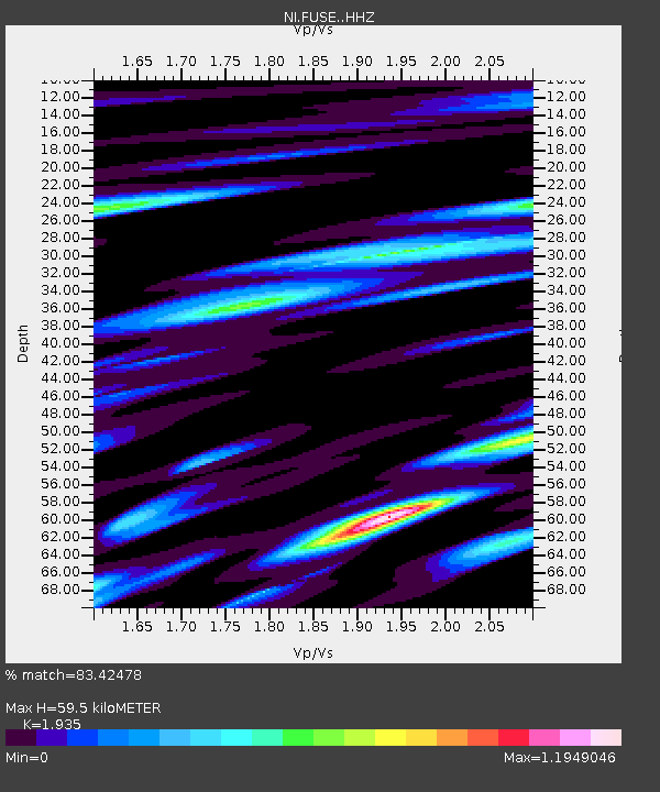
| Estimated Moho Depth: |
59.5 km |
| Estimated Crust Vp/Vs: |
1.93 |
| Assumed Crust Vp: |
6.35 km/s |
| Estimated Crust Vs: |
3.282 km/s |
| Estimated Crust Poisson's Ratio: |
0.32 |
|
| Radial Match: |
83.42478 % |
| Radial Bump: |
400 |
| Transverse Match: |
71.08451 % |
| Transverse Bump: |
400 |
| SOD ConfigId: |
7422571 |
| Insert Time: |
2019-04-20 12:23:49.784 +0000 |
| GWidth: |
2.5 |
| Max Bumps: |
400 |
| Tol: |
0.001 |
|

Signal To Noise
| Channel | StoN | STA | LTA |
| NI:FUSE: :HHZ:20150817T16:24:51.767987Z | 4.3757668 | 2.8909113E-7 | 6.606639E-8 |
| NI:FUSE: :HHN:20150817T16:24:51.767987Z | 1.9597111 | 1.2053917E-7 | 6.150864E-8 |
| NI:FUSE: :HHE:20150817T16:24:51.767987Z | 1.8961424 | 1.1427373E-7 | 6.026643E-8 |
| Arrivals |
| Ps | 9.3 SECOND |
| PpPs | 26 SECOND |
| PsPs/PpSs | 35 SECOND |


