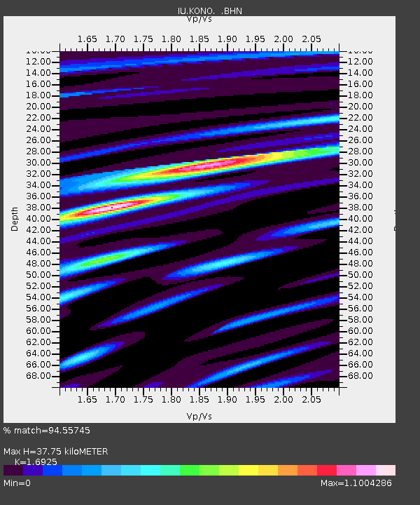
KONO Kongsberg, Norway - Earthquake Result Viewer

Earthquake location: Hindu Kush Region, Afghanistan
Earthquake latitude/longitude: 36.4/70.9
Earthquake time(UTC): 1997/05/13 (133) 14:13:45 GMT
Earthquake Depth: 196 km
Earthquake Magnitude: 6.1 MB, 6.5 UNKNOWN, 6.4 MW
Earthquake Catalog/Contributor: WHDF/NEIC
Network: IU Global Seismograph Network (GSN - IRIS/USGS)
Station: KONO Kongsberg, Norway
Lat/Lon: 59.65 N/9.60 E
Elevation: 216 m
Distance: 45.1 deg
Az: 321.036 deg
Baz: 92.677 deg
Ray Param: 0.07073144
Estimated Moho Depth: 37.75 km
Estimated Crust Vp/Vs: 1.69
Assumed Crust Vp: 6.545 km/s
Estimated Crust Vs: 3.867 km/s
Estimated Crust Poisson's Ratio: 0.23
Radial Match: 94.55745 %
Radial Bump: 355
Transverse Match: 83.61504 %
Transverse Bump: 400
SOD ConfigId: 6273
Insert Time: 2010-03-04 15:55:41.859 +0000
GWidth: 2.5
Max Bumps: 400
Tol: 0.001

Signal To Noise

ChannelStoNSTALTA
IU:KONO: :BHN:19970513T14:21:11.97301Z3.99816517.664421E-71.9169846E-7
IU:KONO: :BHE:19970513T14:21:11.973987Z30.7341923.7847024E-61.2314305E-7
IU:KONO: :BHZ:19970513T14:21:11.97301Z21.9408077.1489017E-63.2582673E-7
Arrivals
Ps4.3 SECOND
PpPs15 SECOND
PsPs/PpSs19 SECOND