You are here: Home > Network List > IU - Global Seismograph Network (GSN - IRIS/USGS) Stations List
> Station PMG Port Moresby, New Guinea > Earthquake Result Viewer
PMG Port Moresby, New Guinea - Earthquake Result Viewer

| Earthquake location: |
Nepal |
| Earthquake latitude/longitude: |
27.8/86.0 |
| Earthquake time(UTC): |
2015/04/26 (116) 07:09:08 GMT |
| Earthquake Depth: |
10 km |
| Earthquake Magnitude: |
6.7 MWP |
| Earthquake Catalog/Contributor: |
NEIC PDE/NEIC COMCAT |
|
| Network: |
IU Global Seismograph Network (GSN - IRIS/USGS) |
| Station: |
PMG Port Moresby, New Guinea |
| Lat/Lon: |
9.40 S/147.16 E |
| Elevation: |
90 m |
|
| Distance: |
69.8 deg |
| Az: |
112.856 deg |
| Baz: |
304.175 deg |
| Ray Param: |
0.055435587 |
| Estimated Moho Depth: |
13.5 km |
| Estimated Crust Vp/Vs: |
2.10 |
| Assumed Crust Vp: |
6.122 km/s |
| Estimated Crust Vs: |
2.919 km/s |
| Estimated Crust Poisson's Ratio: |
0.35 |
|
| Radial Match: |
92.16821 % |
| Radial Bump: |
400 |
| Transverse Match: |
88.702736 % |
| Transverse Bump: |
400 |
| SOD ConfigId: |
872571 |
| Insert Time: |
2015-05-10 07:39:01.930 +0000 |
| GWidth: |
2.5 |
| Max Bumps: |
400 |
| Tol: |
0.001 |
|
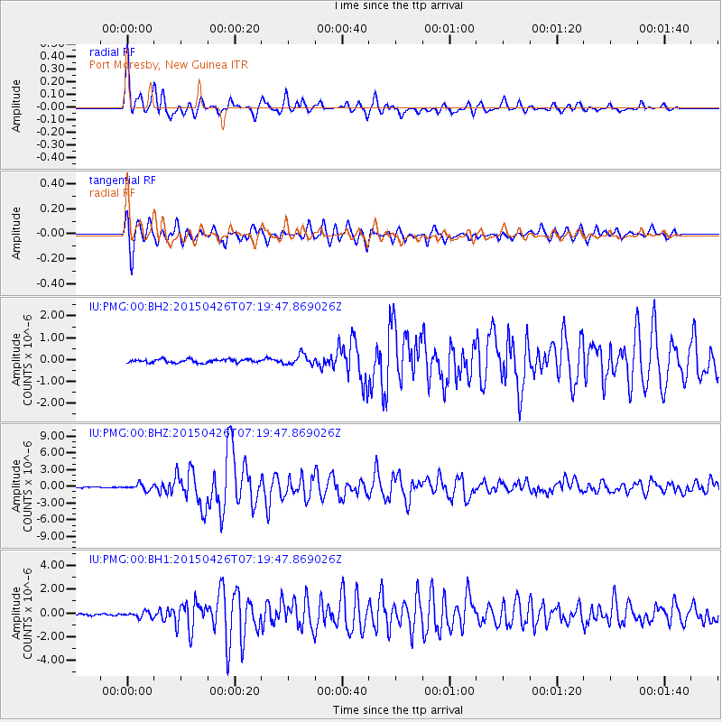
Signal To Noise
| Channel | StoN | STA | LTA |
| IU:PMG:00:BHZ:20150426T07:19:47.869026Z | 8.621086 | 5.337405E-7 | 6.1911045E-8 |
| IU:PMG:00:BH1:20150426T07:19:47.869026Z | 2.763925 | 2.4170225E-7 | 8.744892E-8 |
| IU:PMG:00:BH2:20150426T07:19:47.869026Z | 3.062839 | 2.3328256E-7 | 7.616547E-8 |
| Arrivals |
| Ps | 2.5 SECOND |
| PpPs | 6.6 SECOND |
| PsPs/PpSs | 9.1 SECOND |


