You are here: Home > Network List > AV - Alaska Volcano Observatory Stations List
> Station AMKA Regional Station, Amchitka Island, Alaska > Earthquake Result Viewer
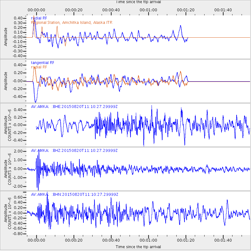
AMKA Regional Station, Amchitka Island, Alaska - Earthquake Result Viewer
*The percent match for this event was below the threshold and hence no stack was calculated.
| Earthquake location: |
Northern Molucca Sea |
| Earthquake latitude/longitude: |
0.5/126.6 |
| Earthquake time(UTC): |
2015/08/20 (232) 11:00:10 GMT |
| Earthquake Depth: |
50 km |
| Earthquake Magnitude: |
5.7 MB |
| Earthquake Catalog/Contributor: |
NEIC PDE/NEIC COMCAT |
|
| Network: |
AV Alaska Volcano Observatory |
| Station: |
AMKA Regional Station, Amchitka Island, Alaska |
| Lat/Lon: |
51.38 N/179.30 E |
| Elevation: |
116 m |
|
| Distance: |
67.2 deg |
| Az: |
32.718 deg |
| Baz: |
239.586 deg |
| Ray Param: |
$rayparam |
*The percent match for this event was below the threshold and hence was not used in the summary stack. |
|
| Radial Match: |
49.64521 % |
| Radial Bump: |
369 |
| Transverse Match: |
66.620224 % |
| Transverse Bump: |
400 |
| SOD ConfigId: |
7422571 |
| Insert Time: |
2019-04-20 12:30:40.641 +0000 |
| GWidth: |
2.5 |
| Max Bumps: |
400 |
| Tol: |
0.001 |
|
Signal To Noise
| Channel | StoN | STA | LTA |
| AV:AMKA: :BHZ:20150820T11:10:27.29999Z | 8.577916 | 8.745432E-7 | 1.0195287E-7 |
| AV:AMKA: :BHN:20150820T11:10:27.29999Z | 1.3868434 | 1.7690525E-7 | 1.2755964E-7 |
| AV:AMKA: :BHE:20150820T11:10:27.29999Z | 1.2865858 | 1.4124512E-7 | 1.097829E-7 |
| Arrivals |
| Ps | |
| PpPs | |
| PsPs/PpSs | |


