You are here: Home > Network List > TA - USArray Transportable Network (new EarthScope stations) Stations List
> Station A21K Barrow, AK, USA > Earthquake Result Viewer
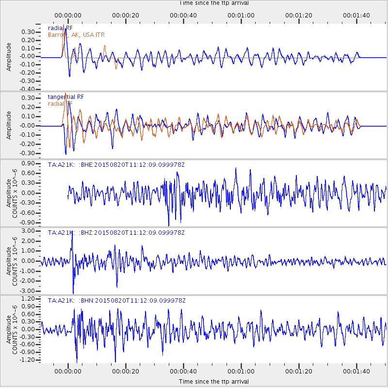
A21K Barrow, AK, USA - Earthquake Result Viewer
*The percent match for this event was below the threshold and hence no stack was calculated.
| Earthquake location: |
Northern Molucca Sea |
| Earthquake latitude/longitude: |
0.5/126.6 |
| Earthquake time(UTC): |
2015/08/20 (232) 11:00:10 GMT |
| Earthquake Depth: |
50 km |
| Earthquake Magnitude: |
5.7 MB |
| Earthquake Catalog/Contributor: |
NEIC PDE/NEIC COMCAT |
|
| Network: |
TA USArray Transportable Network (new EarthScope stations) |
| Station: |
A21K Barrow, AK, USA |
| Lat/Lon: |
71.32 N/156.62 W |
| Elevation: |
577 m |
|
| Distance: |
85.3 deg |
| Az: |
18.342 deg |
| Baz: |
257.605 deg |
| Ray Param: |
$rayparam |
*The percent match for this event was below the threshold and hence was not used in the summary stack. |
|
| Radial Match: |
72.12384 % |
| Radial Bump: |
400 |
| Transverse Match: |
70.37217 % |
| Transverse Bump: |
400 |
| SOD ConfigId: |
7422571 |
| Insert Time: |
2019-04-20 12:32:57.736 +0000 |
| GWidth: |
2.5 |
| Max Bumps: |
400 |
| Tol: |
0.001 |
|
Signal To Noise
| Channel | StoN | STA | LTA |
| TA:A21K: :BHZ:20150820T11:12:09.099978Z | 4.631046 | 1.0467892E-6 | 2.2603733E-7 |
| TA:A21K: :BHN:20150820T11:12:09.099978Z | 2.5859823 | 4.4655525E-7 | 1.7268303E-7 |
| TA:A21K: :BHE:20150820T11:12:09.099978Z | 1.8468074 | 3.240981E-7 | 1.7549101E-7 |
| Arrivals |
| Ps | |
| PpPs | |
| PsPs/PpSs | |


