You are here: Home > Network List > TA - USArray Transportable Network (new EarthScope stations) Stations List
> Station I23K Minto, Yukon-Koyukuk, AK, USA > Earthquake Result Viewer
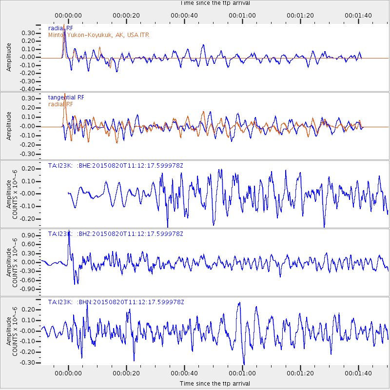
I23K Minto, Yukon-Koyukuk, AK, USA - Earthquake Result Viewer
*The percent match for this event was below the threshold and hence no stack was calculated.
| Earthquake location: |
Northern Molucca Sea |
| Earthquake latitude/longitude: |
0.5/126.6 |
| Earthquake time(UTC): |
2015/08/20 (232) 11:00:10 GMT |
| Earthquake Depth: |
50 km |
| Earthquake Magnitude: |
5.7 MB |
| Earthquake Catalog/Contributor: |
NEIC PDE/NEIC COMCAT |
|
| Network: |
TA USArray Transportable Network (new EarthScope stations) |
| Station: |
I23K Minto, Yukon-Koyukuk, AK, USA |
| Lat/Lon: |
65.15 N/149.36 W |
| Elevation: |
149 m |
|
| Distance: |
87.0 deg |
| Az: |
24.89 deg |
| Baz: |
264.79 deg |
| Ray Param: |
$rayparam |
*The percent match for this event was below the threshold and hence was not used in the summary stack. |
|
| Radial Match: |
68.88942 % |
| Radial Bump: |
397 |
| Transverse Match: |
64.90966 % |
| Transverse Bump: |
400 |
| SOD ConfigId: |
7422571 |
| Insert Time: |
2019-04-20 12:33:02.233 +0000 |
| GWidth: |
2.5 |
| Max Bumps: |
400 |
| Tol: |
0.001 |
|
Signal To Noise
| Channel | StoN | STA | LTA |
| TA:I23K: :BHZ:20150820T11:12:17.599978Z | 6.829734 | 4.1415322E-7 | 6.063973E-8 |
| TA:I23K: :BHN:20150820T11:12:17.599978Z | 2.2808797 | 9.606172E-8 | 4.211608E-8 |
| TA:I23K: :BHE:20150820T11:12:17.599978Z | 2.0483327 | 9.9069666E-8 | 4.8366E-8 |
| Arrivals |
| Ps | |
| PpPs | |
| PsPs/PpSs | |


