You are here: Home > Network List > TA - USArray Transportable Network (new EarthScope stations) Stations List
> Station POKR Poker Plat Research Range, AK, USA > Earthquake Result Viewer
POKR Poker Plat Research Range, AK, USA - Earthquake Result Viewer

| Earthquake location: |
Nepal |
| Earthquake latitude/longitude: |
27.8/86.0 |
| Earthquake time(UTC): |
2015/04/26 (116) 07:09:08 GMT |
| Earthquake Depth: |
10 km |
| Earthquake Magnitude: |
6.7 MWP |
| Earthquake Catalog/Contributor: |
NEIC PDE/NEIC COMCAT |
|
| Network: |
TA USArray Transportable Network (new EarthScope stations) |
| Station: |
POKR Poker Plat Research Range, AK, USA |
| Lat/Lon: |
65.12 N/147.43 W |
| Elevation: |
501 m |
|
| Distance: |
78.6 deg |
| Az: |
20.272 deg |
| Baz: |
313.49 deg |
| Ray Param: |
0.049499262 |
| Estimated Moho Depth: |
34.25 km |
| Estimated Crust Vp/Vs: |
1.72 |
| Assumed Crust Vp: |
6.566 km/s |
| Estimated Crust Vs: |
3.812 km/s |
| Estimated Crust Poisson's Ratio: |
0.25 |
|
| Radial Match: |
95.738625 % |
| Radial Bump: |
400 |
| Transverse Match: |
89.23246 % |
| Transverse Bump: |
400 |
| SOD ConfigId: |
872571 |
| Insert Time: |
2015-05-10 07:40:18.452 +0000 |
| GWidth: |
2.5 |
| Max Bumps: |
400 |
| Tol: |
0.001 |
|
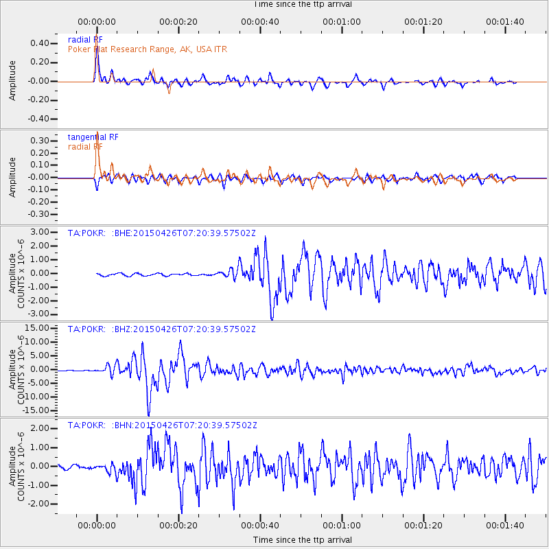
Signal To Noise
| Channel | StoN | STA | LTA |
| TA:POKR: :BHZ:20150426T07:20:39.57502Z | 22.70571 | 1.5438488E-6 | 6.799386E-8 |
| TA:POKR: :BHN:20150426T07:20:39.57502Z | 2.4041557 | 2.1468254E-7 | 8.9296435E-8 |
| TA:POKR: :BHE:20150426T07:20:39.57502Z | 3.9231884 | 3.3143652E-7 | 8.448142E-8 |
| Arrivals |
| Ps | 3.9 SECOND |
| PpPs | 14 SECOND |
| PsPs/PpSs | 18 SECOND |


