You are here: Home > Network List > AG - Arkansas Seismic Network Stations List
> Station LCAR Lake Charles,AR > Earthquake Result Viewer
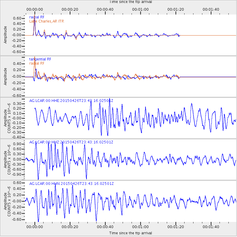
LCAR Lake Charles,AR - Earthquake Result Viewer
*The percent match for this event was below the threshold and hence no stack was calculated.
| Earthquake location: |
Near Coast Of Northern Peru |
| Earthquake latitude/longitude: |
-8.3/-79.8 |
| Earthquake time(UTC): |
2015/04/26 (116) 23:35:29 GMT |
| Earthquake Depth: |
22 km |
| Earthquake Magnitude: |
5.6 MWW, 5.6 MWB, 5.7 MWC |
| Earthquake Catalog/Contributor: |
NEIC PDE/NEIC COMCAT |
|
| Network: |
AG Arkansas Seismic Network |
| Station: |
LCAR Lake Charles,AR |
| Lat/Lon: |
36.07 N/91.15 W |
| Elevation: |
103 m |
|
| Distance: |
45.4 deg |
| Az: |
347.073 deg |
| Baz: |
164.142 deg |
| Ray Param: |
$rayparam |
*The percent match for this event was below the threshold and hence was not used in the summary stack. |
|
| Radial Match: |
76.66494 % |
| Radial Bump: |
271 |
| Transverse Match: |
64.22808 % |
| Transverse Bump: |
400 |
| SOD ConfigId: |
872571 |
| Insert Time: |
2015-05-10 23:47:56.334 +0000 |
| GWidth: |
2.5 |
| Max Bumps: |
400 |
| Tol: |
0.001 |
|
Signal To Noise
| Channel | StoN | STA | LTA |
| AG:LCAR:00:HHZ:20150426T23:43:16.02501Z | 4.5888553 | 5.33979E-7 | 1.16364326E-7 |
| AG:LCAR:00:HHN:20150426T23:43:16.02501Z | 5.516706 | 2.9637806E-7 | 5.3723735E-8 |
| AG:LCAR:00:HHE:20150426T23:43:16.02501Z | 1.5680556 | 1.5489773E-7 | 9.878332E-8 |
| Arrivals |
| Ps | |
| PpPs | |
| PsPs/PpSs | |


