You are here: Home > Network List > IU - Global Seismograph Network (GSN - IRIS/USGS) Stations List
> Station KONO Kongsberg, Norway > Earthquake Result Viewer
KONO Kongsberg, Norway - Earthquake Result Viewer

| Earthquake location: |
Kuril Islands |
| Earthquake latitude/longitude: |
44.3/148.4 |
| Earthquake time(UTC): |
2001/05/25 (145) 00:40:50 GMT |
| Earthquake Depth: |
33 km |
| Earthquake Magnitude: |
6.1 MB, 6.7 MS, 6.7 MW, 6.6 MW |
| Earthquake Catalog/Contributor: |
WHDF/NEIC |
|
| Network: |
IU Global Seismograph Network (GSN - IRIS/USGS) |
| Station: |
KONO Kongsberg, Norway |
| Lat/Lon: |
59.65 N/9.60 E |
| Elevation: |
216 m |
|
| Distance: |
71.0 deg |
| Az: |
339.286 deg |
| Baz: |
30.026 deg |
| Ray Param: |
0.05452807 |
| Estimated Moho Depth: |
15.5 km |
| Estimated Crust Vp/Vs: |
2.10 |
| Assumed Crust Vp: |
6.545 km/s |
| Estimated Crust Vs: |
3.124 km/s |
| Estimated Crust Poisson's Ratio: |
0.35 |
|
| Radial Match: |
92.78876 % |
| Radial Bump: |
304 |
| Transverse Match: |
76.917915 % |
| Transverse Bump: |
400 |
| SOD ConfigId: |
4714 |
| Insert Time: |
2010-03-04 15:57:16.431 +0000 |
| GWidth: |
2.5 |
| Max Bumps: |
400 |
| Tol: |
0.001 |
|
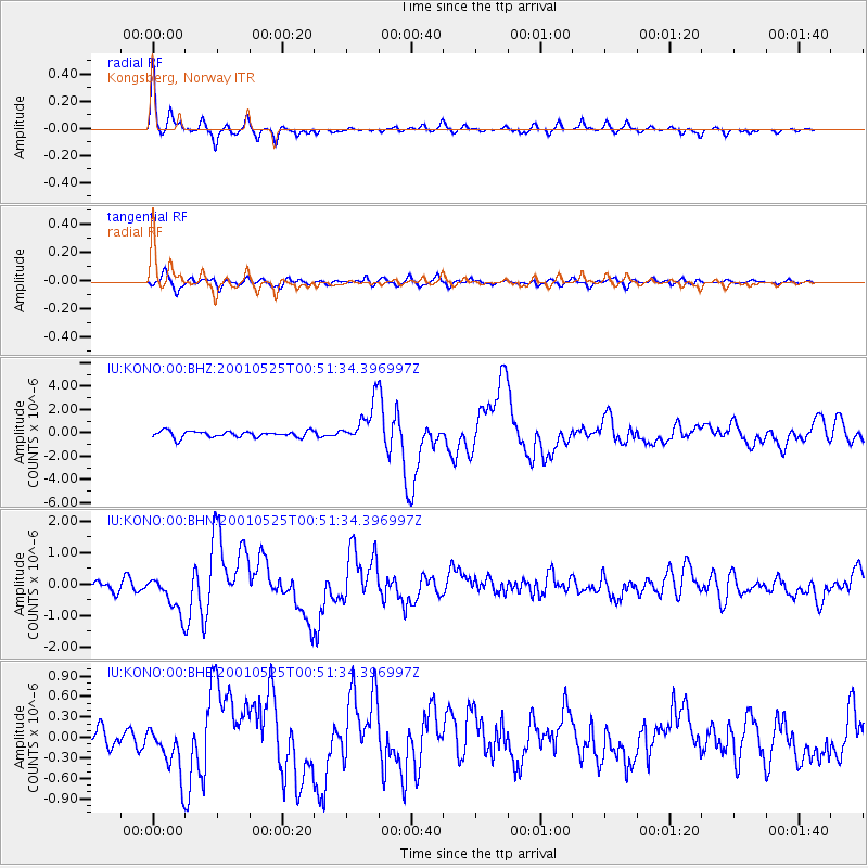
Signal To Noise
| Channel | StoN | STA | LTA |
| IU:KONO:00:BHN:20010525T00:51:34.396997Z | 3.27431 | 6.1669056E-7 | 1.8834213E-7 |
| IU:KONO:00:BHE:20010525T00:51:34.396997Z | 2.6173506 | 3.8184442E-7 | 1.4588967E-7 |
| IU:KONO:00:BHZ:20010525T00:51:34.396997Z | 6.670218 | 1.7552478E-6 | 2.63147E-7 |
| Arrivals |
| Ps | 2.7 SECOND |
| PpPs | 7.1 SECOND |
| PsPs/PpSs | 9.8 SECOND |


