You are here: Home > Network List > IU - Global Seismograph Network (GSN - IRIS/USGS) Stations List
> Station RSSD Black Hills, South Dakota, USA > Earthquake Result Viewer
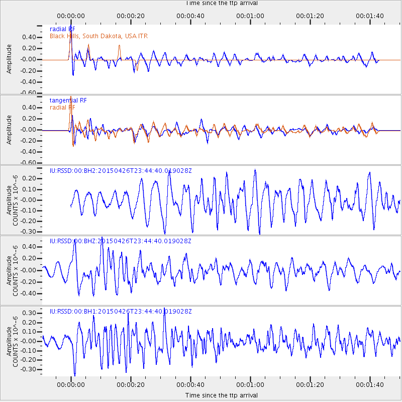
RSSD Black Hills, South Dakota, USA - Earthquake Result Viewer
*The percent match for this event was below the threshold and hence no stack was calculated.
| Earthquake location: |
Near Coast Of Northern Peru |
| Earthquake latitude/longitude: |
-8.3/-79.8 |
| Earthquake time(UTC): |
2015/04/26 (116) 23:35:29 GMT |
| Earthquake Depth: |
22 km |
| Earthquake Magnitude: |
5.6 MWW, 5.6 MWB, 5.7 MWC |
| Earthquake Catalog/Contributor: |
NEIC PDE/NEIC COMCAT |
|
| Network: |
IU Global Seismograph Network (GSN - IRIS/USGS) |
| Station: |
RSSD Black Hills, South Dakota, USA |
| Lat/Lon: |
44.12 N/104.04 W |
| Elevation: |
2090 m |
|
| Distance: |
56.6 deg |
| Az: |
339.272 deg |
| Baz: |
150.9 deg |
| Ray Param: |
$rayparam |
*The percent match for this event was below the threshold and hence was not used in the summary stack. |
|
| Radial Match: |
69.09078 % |
| Radial Bump: |
400 |
| Transverse Match: |
55.88697 % |
| Transverse Bump: |
375 |
| SOD ConfigId: |
872571 |
| Insert Time: |
2015-05-10 23:49:53.004 +0000 |
| GWidth: |
2.5 |
| Max Bumps: |
400 |
| Tol: |
0.001 |
|
Signal To Noise
| Channel | StoN | STA | LTA |
| IU:RSSD:00:BHZ:20150426T23:44:40.019028Z | 3.1648932 | 2.597033E-7 | 8.2057525E-8 |
| IU:RSSD:00:BH1:20150426T23:44:40.019028Z | 2.138795 | 1.5355647E-7 | 7.1795796E-8 |
| IU:RSSD:00:BH2:20150426T23:44:40.019028Z | 2.1258175 | 1.6726946E-7 | 7.868477E-8 |
| Arrivals |
| Ps | |
| PpPs | |
| PsPs/PpSs | |


