You are here: Home > Network List > US - United States National Seismic Network Stations List
> Station MSO Missoula, Montana, USA > Earthquake Result Viewer
MSO Missoula, Montana, USA - Earthquake Result Viewer
*The percent match for this event was below the threshold and hence no stack was calculated.
| Earthquake location: |
South Of Fiji Islands |
| Earthquake latitude/longitude: |
-22.4/-178.2 |
| Earthquake time(UTC): |
2015/08/21 (233) 18:45:39 GMT |
| Earthquake Depth: |
370 km |
| Earthquake Magnitude: |
5.3 MW |
| Earthquake Catalog/Contributor: |
ISC/ISC |
|
| Network: |
US United States National Seismic Network |
| Station: |
MSO Missoula, Montana, USA |
| Lat/Lon: |
46.83 N/113.94 W |
| Elevation: |
1264 m |
|
| Distance: |
89.9 deg |
| Az: |
38.197 deg |
| Baz: |
236.468 deg |
| Ray Param: |
$rayparam |
*The percent match for this event was below the threshold and hence was not used in the summary stack. |
|
| Radial Match: |
28.661411 % |
| Radial Bump: |
400 |
| Transverse Match: |
39.08881 % |
| Transverse Bump: |
400 |
| SOD ConfigId: |
7422571 |
| Insert Time: |
2019-04-20 12:47:19.038 +0000 |
| GWidth: |
2.5 |
| Max Bumps: |
400 |
| Tol: |
0.001 |
|
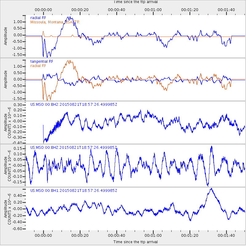
Signal To Noise
| Channel | StoN | STA | LTA |
| US:MSO:00:BHZ:20150821T18:57:26.499985Z | 0.7403151 | 5.7155987E-8 | 7.720495E-8 |
| US:MSO:00:BH1:20150821T18:57:26.499985Z | 0.43074203 | 6.630991E-8 | 1.5394345E-7 |
| US:MSO:00:BH2:20150821T18:57:26.499985Z | 0.4001072 | 5.6733747E-8 | 1.4179636E-7 |
| Arrivals |
| Ps | |
| PpPs | |
| PsPs/PpSs | |


