You are here: Home > Network List > UW - Pacific Northwest Regional Seismic Network Stations List
> Station MRBL Marblemount, WA, USA > Earthquake Result Viewer
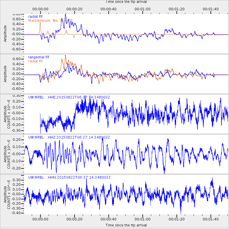
MRBL Marblemount, WA, USA - Earthquake Result Viewer
*The percent match for this event was below the threshold and hence no stack was calculated.
| Earthquake location: |
Mariana Islands |
| Earthquake latitude/longitude: |
14.8/146.8 |
| Earthquake time(UTC): |
2015/08/22 (234) 06:25:38 GMT |
| Earthquake Depth: |
33 km |
| Earthquake Magnitude: |
5.2 MW |
| Earthquake Catalog/Contributor: |
ISC/ISC |
|
| Network: |
UW Pacific Northwest Regional Seismic Network |
| Station: |
MRBL Marblemount, WA, USA |
| Lat/Lon: |
48.52 N/121.48 W |
| Elevation: |
75 m |
|
| Distance: |
80.2 deg |
| Az: |
42.416 deg |
| Baz: |
281.113 deg |
| Ray Param: |
$rayparam |
*The percent match for this event was below the threshold and hence was not used in the summary stack. |
|
| Radial Match: |
30.519754 % |
| Radial Bump: |
400 |
| Transverse Match: |
49.17789 % |
| Transverse Bump: |
400 |
| SOD ConfigId: |
7422571 |
| Insert Time: |
2019-04-20 13:01:28.710 +0000 |
| GWidth: |
2.5 |
| Max Bumps: |
400 |
| Tol: |
0.001 |
|
Signal To Noise
| Channel | StoN | STA | LTA |
| UW:MRBL: :HHZ:20150822T06:37:14.348003Z | 1.4353586 | 8.306806E-8 | 5.7872686E-8 |
| UW:MRBL: :HHN:20150822T06:37:14.348003Z | 1.444894 | 1.3853703E-7 | 9.588041E-8 |
| UW:MRBL: :HHE:20150822T06:37:14.348003Z | 2.0318096 | 2.3518842E-7 | 1.1575318E-7 |
| Arrivals |
| Ps | |
| PpPs | |
| PsPs/PpSs | |


