You are here: Home > Network List > US - United States National Seismic Network Stations List
> Station WMOK Wichita Mountains, Oklahoma, USA > Earthquake Result Viewer
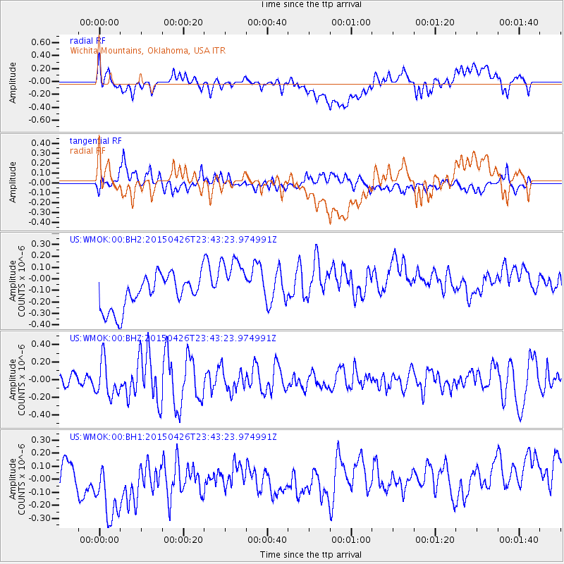
WMOK Wichita Mountains, Oklahoma, USA - Earthquake Result Viewer
*The percent match for this event was below the threshold and hence no stack was calculated.
| Earthquake location: |
Near Coast Of Northern Peru |
| Earthquake latitude/longitude: |
-8.3/-79.8 |
| Earthquake time(UTC): |
2015/04/26 (116) 23:35:29 GMT |
| Earthquake Depth: |
22 km |
| Earthquake Magnitude: |
5.6 MWW, 5.6 MWB, 5.7 MWC |
| Earthquake Catalog/Contributor: |
NEIC PDE/NEIC COMCAT |
|
| Network: |
US United States National Seismic Network |
| Station: |
WMOK Wichita Mountains, Oklahoma, USA |
| Lat/Lon: |
34.74 N/98.78 W |
| Elevation: |
486 m |
|
| Distance: |
46.4 deg |
| Az: |
338.314 deg |
| Baz: |
153.638 deg |
| Ray Param: |
$rayparam |
*The percent match for this event was below the threshold and hence was not used in the summary stack. |
|
| Radial Match: |
42.41396 % |
| Radial Bump: |
400 |
| Transverse Match: |
49.917683 % |
| Transverse Bump: |
400 |
| SOD ConfigId: |
872571 |
| Insert Time: |
2015-05-10 23:52:36.841 +0000 |
| GWidth: |
2.5 |
| Max Bumps: |
400 |
| Tol: |
0.001 |
|
Signal To Noise
| Channel | StoN | STA | LTA |
| US:WMOK:00:BHZ:20150426T23:43:23.974991Z | 2.597233 | 2.0696896E-7 | 7.968825E-8 |
| US:WMOK:00:BH1:20150426T23:43:23.974991Z | 1.8959464 | 3.9330428E-7 | 2.0744484E-7 |
| US:WMOK:00:BH2:20150426T23:43:23.974991Z | 1.659906 | 2.4207432E-7 | 1.4583617E-7 |
| Arrivals |
| Ps | |
| PpPs | |
| PsPs/PpSs | |


