You are here: Home > Network List > CI - Caltech Regional Seismic Network Stations List
> Station SWS Sam W. Stewart, Westmorland, CA, USA > Earthquake Result Viewer
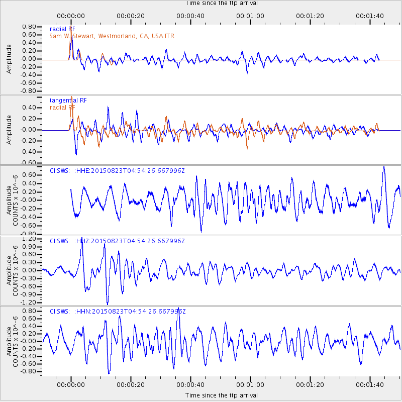
SWS Sam W. Stewart, Westmorland, CA, USA - Earthquake Result Viewer
*The percent match for this event was below the threshold and hence no stack was calculated.
| Earthquake location: |
Near Coast Of Guatemala |
| Earthquake latitude/longitude: |
13.1/-90.3 |
| Earthquake time(UTC): |
2015/08/23 (235) 04:48:46 GMT |
| Earthquake Depth: |
32 km |
| Earthquake Magnitude: |
5.5 MW |
| Earthquake Catalog/Contributor: |
ISC/ISC |
|
| Network: |
CI Caltech Regional Seismic Network |
| Station: |
SWS Sam W. Stewart, Westmorland, CA, USA |
| Lat/Lon: |
32.94 N/115.80 W |
| Elevation: |
140 m |
|
| Distance: |
30.6 deg |
| Az: |
314.545 deg |
| Baz: |
124.324 deg |
| Ray Param: |
$rayparam |
*The percent match for this event was below the threshold and hence was not used in the summary stack. |
|
| Radial Match: |
74.35608 % |
| Radial Bump: |
384 |
| Transverse Match: |
65.8514 % |
| Transverse Bump: |
365 |
| SOD ConfigId: |
7422571 |
| Insert Time: |
2019-04-20 13:17:49.552 +0000 |
| GWidth: |
2.5 |
| Max Bumps: |
400 |
| Tol: |
0.001 |
|
Signal To Noise
| Channel | StoN | STA | LTA |
| CI:SWS: :HHZ:20150823T04:54:26.667996Z | 7.1252213 | 4.57573E-7 | 6.421878E-8 |
| CI:SWS: :HHN:20150823T04:54:26.667996Z | 1.8017311 | 2.3486423E-7 | 1.3035476E-7 |
| CI:SWS: :HHE:20150823T04:54:26.667996Z | 1.1765774 | 2.3441915E-7 | 1.9923817E-7 |
| Arrivals |
| Ps | |
| PpPs | |
| PsPs/PpSs | |


