You are here: Home > Network List > TA - USArray Transportable Network (new EarthScope stations) Stations List
> Station D62A Allapoint, Allagash, ME, USA > Earthquake Result Viewer
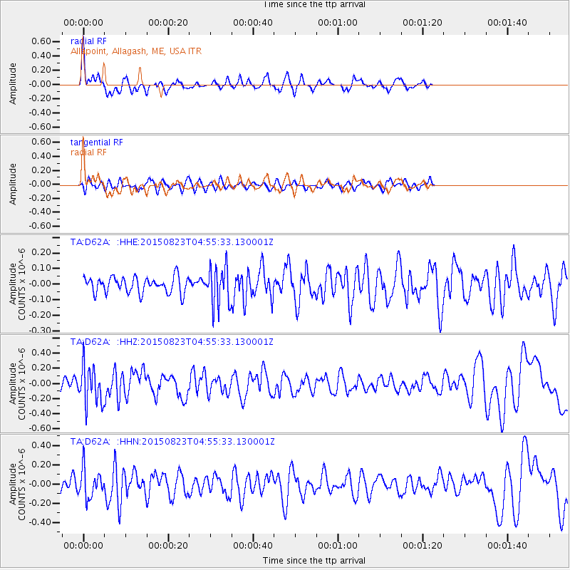
D62A Allapoint, Allagash, ME, USA - Earthquake Result Viewer
*The percent match for this event was below the threshold and hence no stack was calculated.
| Earthquake location: |
Near Coast Of Guatemala |
| Earthquake latitude/longitude: |
13.1/-90.3 |
| Earthquake time(UTC): |
2015/08/23 (235) 04:48:46 GMT |
| Earthquake Depth: |
32 km |
| Earthquake Magnitude: |
5.5 MW |
| Earthquake Catalog/Contributor: |
ISC/ISC |
|
| Network: |
TA USArray Transportable Network (new EarthScope stations) |
| Station: |
D62A Allapoint, Allagash, ME, USA |
| Lat/Lon: |
47.08 N/69.05 W |
| Elevation: |
189 m |
|
| Distance: |
38.3 deg |
| Az: |
23.518 deg |
| Baz: |
214.677 deg |
| Ray Param: |
$rayparam |
*The percent match for this event was below the threshold and hence was not used in the summary stack. |
|
| Radial Match: |
67.131584 % |
| Radial Bump: |
363 |
| Transverse Match: |
45.36316 % |
| Transverse Bump: |
395 |
| SOD ConfigId: |
7422571 |
| Insert Time: |
2019-04-20 13:21:27.729 +0000 |
| GWidth: |
2.5 |
| Max Bumps: |
400 |
| Tol: |
0.001 |
|
Signal To Noise
| Channel | StoN | STA | LTA |
| TA:D62A: :HHZ:20150823T04:55:33.130001Z | 2.4181771 | 2.522329E-7 | 1.0430704E-7 |
| TA:D62A: :HHN:20150823T04:55:33.130001Z | 1.7264702 | 1.516127E-7 | 8.781657E-8 |
| TA:D62A: :HHE:20150823T04:55:33.130001Z | 2.4698126 | 1.2675052E-7 | 5.1319898E-8 |
| Arrivals |
| Ps | |
| PpPs | |
| PsPs/PpSs | |


