You are here: Home > Network List > UU - University of Utah Regional Network Stations List
> Station MTPU Mt. Pierson, UT, USA > Earthquake Result Viewer
MTPU Mt. Pierson, UT, USA - Earthquake Result Viewer
| Earthquake location: |
Near Coast Of Guatemala |
| Earthquake latitude/longitude: |
13.1/-90.3 |
| Earthquake time(UTC): |
2015/08/23 (235) 04:48:46 GMT |
| Earthquake Depth: |
32 km |
| Earthquake Magnitude: |
5.5 MW |
| Earthquake Catalog/Contributor: |
ISC/ISC |
|
| Network: |
UU University of Utah Regional Network |
| Station: |
MTPU Mt. Pierson, UT, USA |
| Lat/Lon: |
38.04 N/112.18 W |
| Elevation: |
3112 m |
|
| Distance: |
31.6 deg |
| Az: |
325.769 deg |
| Baz: |
136.034 deg |
| Ray Param: |
0.078958414 |
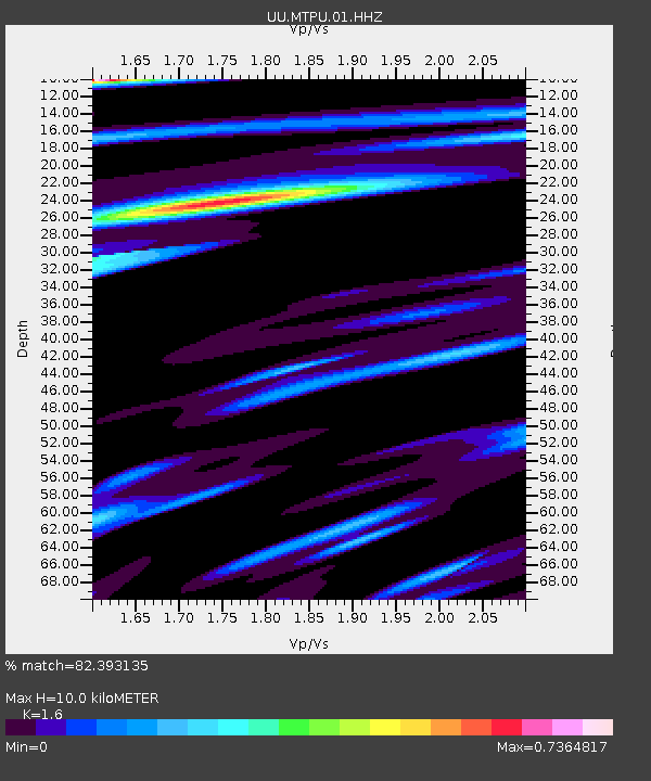
| Estimated Moho Depth: |
10.0 km |
| Estimated Crust Vp/Vs: |
1.60 |
| Assumed Crust Vp: |
6.276 km/s |
| Estimated Crust Vs: |
3.922 km/s |
| Estimated Crust Poisson's Ratio: |
0.18 |
|
| Radial Match: |
82.393135 % |
| Radial Bump: |
400 |
| Transverse Match: |
60.080723 % |
| Transverse Bump: |
400 |
| SOD ConfigId: |
7422571 |
| Insert Time: |
2019-04-20 13:22:54.843 +0000 |
| GWidth: |
2.5 |
| Max Bumps: |
400 |
| Tol: |
0.001 |
|

Signal To Noise
| Channel | StoN | STA | LTA |
| UU:MTPU:01:HHZ:20150823T04:54:35.718014Z | 2.7170856 | 9.159742E-9 | 3.3711647E-9 |
| UU:MTPU:01:HHN:20150823T04:54:35.718014Z | 2.3189397 | 5.0743445E-9 | 2.1882176E-9 |
| UU:MTPU:01:HHE:20150823T04:54:35.718014Z | 1.6381179 | 3.0924976E-9 | 1.8878357E-9 |
| Arrivals |
| Ps | 1.0 SECOND |
| PpPs | 3.8 SECOND |
| PsPs/PpSs | 4.8 SECOND |


