You are here: Home > Network List > UW - Pacific Northwest Regional Seismic Network Stations List
> Station UMAT Pilot Rock, OR, USA > Earthquake Result Viewer
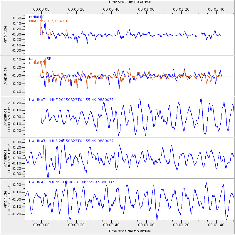
UMAT Pilot Rock, OR, USA - Earthquake Result Viewer
*The percent match for this event was below the threshold and hence no stack was calculated.
| Earthquake location: |
Near Coast Of Guatemala |
| Earthquake latitude/longitude: |
13.1/-90.3 |
| Earthquake time(UTC): |
2015/08/23 (235) 04:48:46 GMT |
| Earthquake Depth: |
32 km |
| Earthquake Magnitude: |
5.5 MW |
| Earthquake Catalog/Contributor: |
ISC/ISC |
|
| Network: |
UW Pacific Northwest Regional Seismic Network |
| Station: |
UMAT Pilot Rock, OR, USA |
| Lat/Lon: |
45.29 N/118.96 W |
| Elevation: |
1318 m |
|
| Distance: |
40.3 deg |
| Az: |
328.399 deg |
| Baz: |
133.671 deg |
| Ray Param: |
$rayparam |
*The percent match for this event was below the threshold and hence was not used in the summary stack. |
|
| Radial Match: |
47.984123 % |
| Radial Bump: |
322 |
| Transverse Match: |
50.788338 % |
| Transverse Bump: |
267 |
| SOD ConfigId: |
7422571 |
| Insert Time: |
2019-04-20 13:23:19.494 +0000 |
| GWidth: |
2.5 |
| Max Bumps: |
400 |
| Tol: |
0.001 |
|
Signal To Noise
| Channel | StoN | STA | LTA |
| UW:UMAT: :HHZ:20150823T04:55:49.988003Z | 3.0208235 | 2.0783243E-7 | 6.879993E-8 |
| UW:UMAT: :HHN:20150823T04:55:49.988003Z | 0.7545232 | 5.998363E-8 | 7.949871E-8 |
| UW:UMAT: :HHE:20150823T04:55:49.988003Z | 1.4851344 | 8.723178E-8 | 5.8736624E-8 |
| Arrivals |
| Ps | |
| PpPs | |
| PsPs/PpSs | |


