You are here: Home > Network List > IU - Global Seismograph Network (GSN - IRIS/USGS) Stations List
> Station RSSD Black Hills, South Dakota, USA > Earthquake Result Viewer
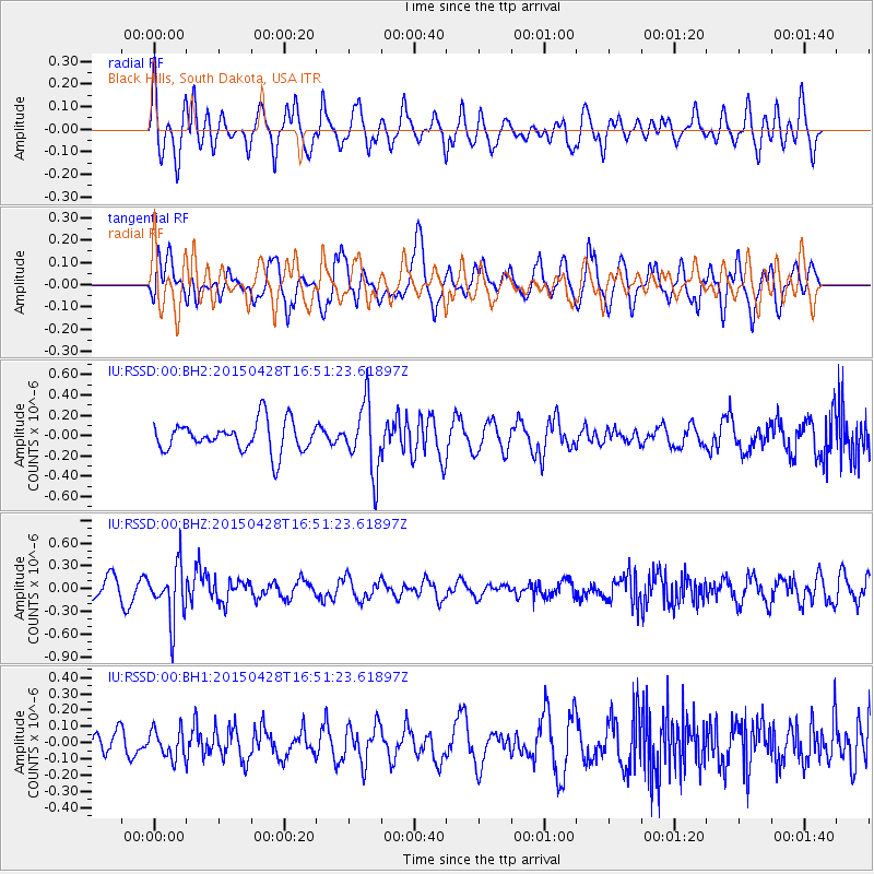
RSSD Black Hills, South Dakota, USA - Earthquake Result Viewer
*The percent match for this event was below the threshold and hence no stack was calculated.
| Earthquake location: |
Fiji Islands Region |
| Earthquake latitude/longitude: |
-20.9/-178.7 |
| Earthquake time(UTC): |
2015/04/28 (118) 16:39:38 GMT |
| Earthquake Depth: |
579 km |
| Earthquake Magnitude: |
6.2 MWB |
| Earthquake Catalog/Contributor: |
NEIC PDE/NEIC COMCAT |
|
| Network: |
IU Global Seismograph Network (GSN - IRIS/USGS) |
| Station: |
RSSD Black Hills, South Dakota, USA |
| Lat/Lon: |
44.12 N/104.04 W |
| Elevation: |
2090 m |
|
| Distance: |
93.9 deg |
| Az: |
44.107 deg |
| Baz: |
244.62 deg |
| Ray Param: |
$rayparam |
*The percent match for this event was below the threshold and hence was not used in the summary stack. |
|
| Radial Match: |
61.00038 % |
| Radial Bump: |
348 |
| Transverse Match: |
59.043053 % |
| Transverse Bump: |
400 |
| SOD ConfigId: |
872571 |
| Insert Time: |
2015-05-12 16:53:55.438 +0000 |
| GWidth: |
2.5 |
| Max Bumps: |
400 |
| Tol: |
0.001 |
|
Signal To Noise
| Channel | StoN | STA | LTA |
| IU:RSSD:00:BHZ:20150428T16:51:23.61897Z | 3.453145 | 3.6161836E-7 | 1.0472146E-7 |
| IU:RSSD:00:BH1:20150428T16:51:23.61897Z | 0.65904015 | 8.758863E-8 | 1.3290332E-7 |
| IU:RSSD:00:BH2:20150428T16:51:23.61897Z | 2.2922707 | 3.372396E-7 | 1.4712033E-7 |
| Arrivals |
| Ps | |
| PpPs | |
| PsPs/PpSs | |


