You are here: Home > Network List > CI - Caltech Regional Seismic Network Stations List
> Station GSC Goldstone, Goldstone Lake, CA, USA > Earthquake Result Viewer
GSC Goldstone, Goldstone Lake, CA, USA - Earthquake Result Viewer
| Earthquake location: |
Rat Islands, Aleutian Islands |
| Earthquake latitude/longitude: |
51.8/177.1 |
| Earthquake time(UTC): |
2006/06/14 (165) 04:18:42 GMT |
| Earthquake Depth: |
14 km |
| Earthquake Magnitude: |
5.9 MB, 6.4 MS, 6.4 MW, 6.4 MW |
| Earthquake Catalog/Contributor: |
WHDF/NEIC |
|
| Network: |
CI Caltech Regional Seismic Network |
| Station: |
GSC Goldstone, Goldstone Lake, CA, USA |
| Lat/Lon: |
35.30 N/116.81 W |
| Elevation: |
1000 m |
|
| Distance: |
49.0 deg |
| Az: |
82.522 deg |
| Baz: |
311.103 deg |
| Ray Param: |
0.069 |
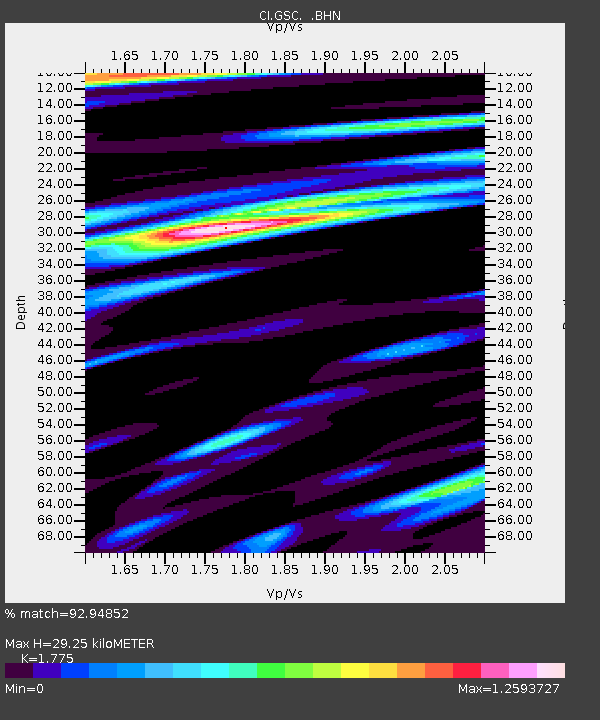
| Estimated Moho Depth: |
29.25 km |
| Estimated Crust Vp/Vs: |
1.77 |
| Assumed Crust Vp: |
6.276 km/s |
| Estimated Crust Vs: |
3.536 km/s |
| Estimated Crust Poisson's Ratio: |
0.27 |
|
| Radial Match: |
92.94852 % |
| Radial Bump: |
400 |
| Transverse Match: |
83.30628 % |
| Transverse Bump: |
400 |
| SOD ConfigId: |
5745 |
| Insert Time: |
2010-02-25 23:39:28.588 +0000 |
| GWidth: |
2.5 |
| Max Bumps: |
400 |
| Tol: |
0.001 |
|
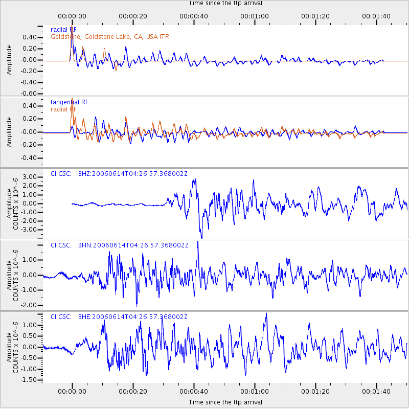
Signal To Noise
| Channel | StoN | STA | LTA |
| CI:GSC: :BHN:20060614T04:26:57.368002Z | 1.4343351 | 1.869298E-7 | 1.3032505E-7 |
| CI:GSC: :BHE:20060614T04:26:57.368002Z | 1.8721534 | 2.4108783E-7 | 1.2877568E-7 |
| CI:GSC: :BHZ:20060614T04:26:57.368002Z | 6.504887 | 5.387572E-7 | 8.2823455E-8 |
| Arrivals |
| Ps | 3.8 SECOND |
| PpPs | 12 SECOND |
| PsPs/PpSs | 16 SECOND |


