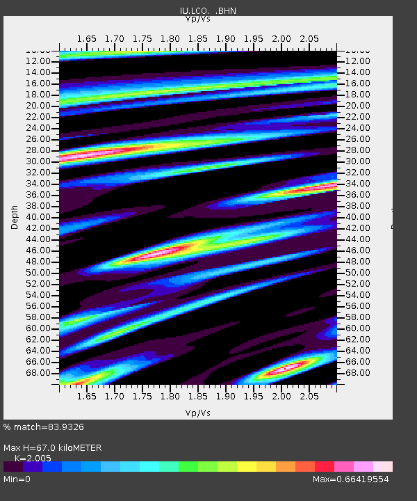
LCO Las Campanas Astronomical Observatory, Chile - Earthquake Result Viewer

Earthquake location: Near Coast Of Chiapas, Mexico
Earthquake latitude/longitude: 14.4/-92.4
Earthquake time(UTC): 2008/10/16 (290) 19:41:25 GMT
Earthquake Depth: 24 km
Earthquake Magnitude: 6.1 MB, 6.6 MS, 6.7 MW, 6.6 MW
Earthquake Catalog/Contributor: WHDF/NEIC
Network: IU Global Seismograph Network (GSN - IRIS/USGS)
Station: LCO Las Campanas Astronomical Observatory, Chile
Lat/Lon: 29.01 S/70.70 W
Elevation: 2299 m
Distance: 48.0 deg
Az: 154.204 deg
Baz: 331.225 deg
Ray Param: 0.06960728
Estimated Moho Depth: 67.0 km
Estimated Crust Vp/Vs: 2.01
Assumed Crust Vp: 6.481 km/s
Estimated Crust Vs: 3.232 km/s
Estimated Crust Poisson's Ratio: 0.33
Radial Match: 83.9326 %
Radial Bump: 400
Transverse Match: 59.964725 %
Transverse Bump: 400
SOD ConfigId: 2556
Insert Time: 2010-03-04 16:01:44.494 +0000
GWidth: 2.5
Max Bumps: 400
Tol: 0.001

Signal To Noise

ChannelStoNSTALTA
IU:LCO: :BHN:20081016T19:49:31.773009Z5.2607592.2405648E-64.2590142E-7
IU:LCO: :BHE:20081016T19:49:31.773009Z2.5276058.9870457E-73.5555576E-7
IU:LCO: :BHZ:20081016T19:49:31.773009Z1.96351056.911184E-73.5198102E-7
Arrivals
Ps11 SECOND
PpPs29 SECOND
PsPs/PpSs40 SECOND