You are here: Home > Network List > CI - Caltech Regional Seismic Network Stations List
> Station GSC Goldstone, Goldstone Lake, CA, USA > Earthquake Result Viewer
GSC Goldstone, Goldstone Lake, CA, USA - Earthquake Result Viewer
| Earthquake location: |
Tonga Islands |
| Earthquake latitude/longitude: |
-20.2/-174.1 |
| Earthquake time(UTC): |
2006/05/03 (123) 15:26:40 GMT |
| Earthquake Depth: |
55 km |
| Earthquake Magnitude: |
7.2 MB, 7.8 MS, 7.9 MW, 7.9 MW |
| Earthquake Catalog/Contributor: |
WHDF/NEIC |
|
| Network: |
CI Caltech Regional Seismic Network |
| Station: |
GSC Goldstone, Goldstone Lake, CA, USA |
| Lat/Lon: |
35.30 N/116.81 W |
| Elevation: |
1000 m |
|
| Distance: |
77.4 deg |
| Az: |
44.856 deg |
| Baz: |
234.095 deg |
| Ray Param: |
0.05021804 |
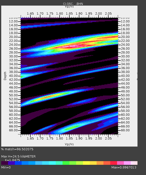
| Estimated Moho Depth: |
24.5 km |
| Estimated Crust Vp/Vs: |
1.85 |
| Assumed Crust Vp: |
6.276 km/s |
| Estimated Crust Vs: |
3.397 km/s |
| Estimated Crust Poisson's Ratio: |
0.29 |
|
| Radial Match: |
96.502075 % |
| Radial Bump: |
400 |
| Transverse Match: |
89.40408 % |
| Transverse Bump: |
400 |
| SOD ConfigId: |
2669 |
| Insert Time: |
2010-02-25 23:39:36.119 +0000 |
| GWidth: |
2.5 |
| Max Bumps: |
400 |
| Tol: |
0.001 |
|
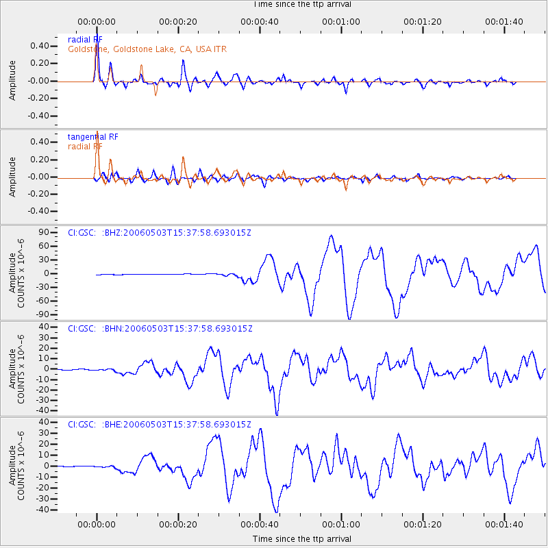
Signal To Noise
| Channel | StoN | STA | LTA |
| CI:GSC: :BHN:20060503T15:37:58.693015Z | 3.664715 | 7.844308E-7 | 2.140496E-7 |
| CI:GSC: :BHE:20060503T15:37:58.693015Z | 3.0603616 | 6.54643E-7 | 2.1391034E-7 |
| CI:GSC: :BHZ:20060503T15:37:58.693015Z | 4.9967914 | 2.535405E-6 | 5.0740664E-7 |
| Arrivals |
| Ps | 3.4 SECOND |
| PpPs | 11 SECOND |
| PsPs/PpSs | 14 SECOND |


