You are here: Home > Network List > US - United States National Seismic Network Stations List
> Station BOZ Bozeman, Montana, USA > Earthquake Result Viewer
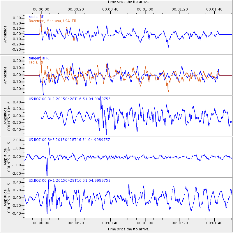
BOZ Bozeman, Montana, USA - Earthquake Result Viewer
*The percent match for this event was below the threshold and hence no stack was calculated.
| Earthquake location: |
Fiji Islands Region |
| Earthquake latitude/longitude: |
-20.9/-178.7 |
| Earthquake time(UTC): |
2015/04/28 (118) 16:39:38 GMT |
| Earthquake Depth: |
579 km |
| Earthquake Magnitude: |
6.2 MWB |
| Earthquake Catalog/Contributor: |
NEIC PDE/NEIC COMCAT |
|
| Network: |
US United States National Seismic Network |
| Station: |
BOZ Bozeman, Montana, USA |
| Lat/Lon: |
45.65 N/111.63 W |
| Elevation: |
1589 m |
|
| Distance: |
89.8 deg |
| Az: |
40.229 deg |
| Baz: |
239.401 deg |
| Ray Param: |
$rayparam |
*The percent match for this event was below the threshold and hence was not used in the summary stack. |
|
| Radial Match: |
77.138084 % |
| Radial Bump: |
400 |
| Transverse Match: |
77.97539 % |
| Transverse Bump: |
400 |
| SOD ConfigId: |
872571 |
| Insert Time: |
2015-05-12 16:56:36.158 +0000 |
| GWidth: |
2.5 |
| Max Bumps: |
400 |
| Tol: |
0.001 |
|
Signal To Noise
| Channel | StoN | STA | LTA |
| US:BOZ:00:BHZ:20150428T16:51:04.998975Z | 5.0069942 | 8.589769E-7 | 1.715554E-7 |
| US:BOZ:00:BH1:20150428T16:51:04.998975Z | 1.4686117 | 1.9615062E-7 | 1.3356194E-7 |
| US:BOZ:00:BH2:20150428T16:51:04.998975Z | 1.9431906 | 2.1591747E-7 | 1.1111492E-7 |
| Arrivals |
| Ps | |
| PpPs | |
| PsPs/PpSs | |


