You are here: Home > Network List > TA - USArray Transportable Network (new EarthScope stations) Stations List
> Station L44A Lake County Forest Preserve, Grayslake, IL, USA > Earthquake Result Viewer
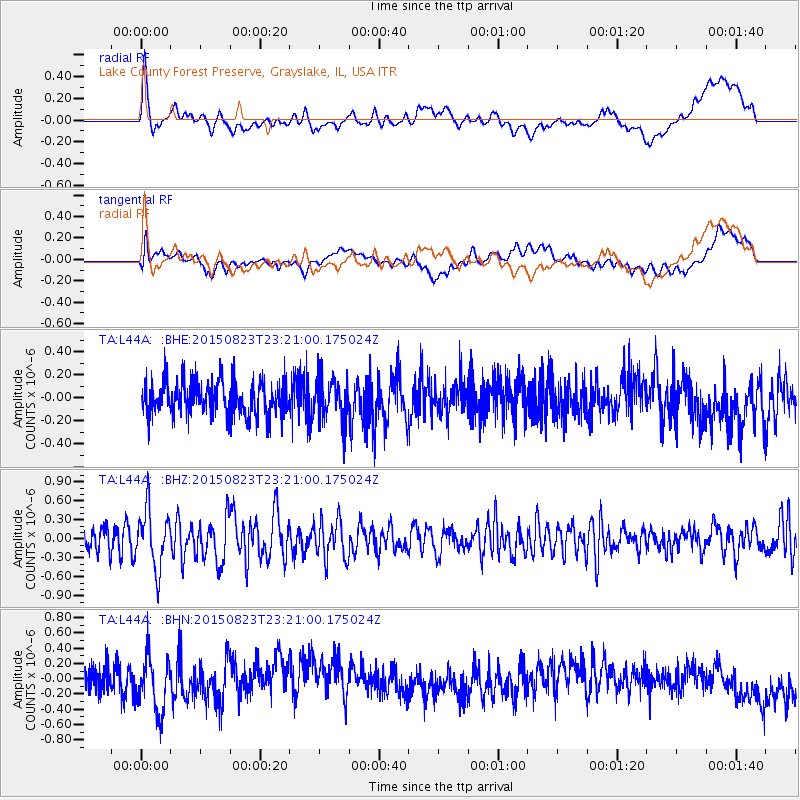
L44A Lake County Forest Preserve, Grayslake, IL, USA - Earthquake Result Viewer
*The percent match for this event was below the threshold and hence no stack was calculated.
| Earthquake location: |
Near Coast Of Central Chile |
| Earthquake latitude/longitude: |
-29.7/-71.4 |
| Earthquake time(UTC): |
2015/08/23 (235) 23:10:03 GMT |
| Earthquake Depth: |
34 km |
| Earthquake Magnitude: |
5.5 MB, 5.5 MB |
| Earthquake Catalog/Contributor: |
NEIC PDE/NEIC ALERT |
|
| Network: |
TA USArray Transportable Network (new EarthScope stations) |
| Station: |
L44A Lake County Forest Preserve, Grayslake, IL, USA |
| Lat/Lon: |
42.18 N/87.91 W |
| Elevation: |
202 m |
|
| Distance: |
73.1 deg |
| Az: |
347.264 deg |
| Baz: |
165.041 deg |
| Ray Param: |
$rayparam |
*The percent match for this event was below the threshold and hence was not used in the summary stack. |
|
| Radial Match: |
60.78767 % |
| Radial Bump: |
400 |
| Transverse Match: |
49.305435 % |
| Transverse Bump: |
400 |
| SOD ConfigId: |
7422571 |
| Insert Time: |
2019-04-20 13:37:11.187 +0000 |
| GWidth: |
2.5 |
| Max Bumps: |
400 |
| Tol: |
0.001 |
|
Signal To Noise
| Channel | StoN | STA | LTA |
| TA:L44A: :BHZ:20150823T23:21:00.175024Z | 2.8230593 | 4.5706346E-7 | 1.619036E-7 |
| TA:L44A: :BHN:20150823T23:21:00.175024Z | 2.3670335 | 3.6268986E-7 | 1.5322549E-7 |
| TA:L44A: :BHE:20150823T23:21:00.175024Z | 1.2370248 | 1.8388161E-7 | 1.4864828E-7 |
| Arrivals |
| Ps | |
| PpPs | |
| PsPs/PpSs | |


