You are here: Home > Network List > TA - USArray Transportable Network (new EarthScope stations) Stations List
> Station WHTX Lake Whitney, Meridian, TX, USA > Earthquake Result Viewer
WHTX Lake Whitney, Meridian, TX, USA - Earthquake Result Viewer
| Earthquake location: |
Near Coast Of Central Chile |
| Earthquake latitude/longitude: |
-29.7/-71.4 |
| Earthquake time(UTC): |
2015/08/23 (235) 23:10:03 GMT |
| Earthquake Depth: |
34 km |
| Earthquake Magnitude: |
5.5 MB, 5.5 MB |
| Earthquake Catalog/Contributor: |
NEIC PDE/NEIC ALERT |
|
| Network: |
TA USArray Transportable Network (new EarthScope stations) |
| Station: |
WHTX Lake Whitney, Meridian, TX, USA |
| Lat/Lon: |
31.99 N/97.46 W |
| Elevation: |
190 m |
|
| Distance: |
66.1 deg |
| Az: |
335.933 deg |
| Baz: |
155.312 deg |
| Ray Param: |
0.05777097 |
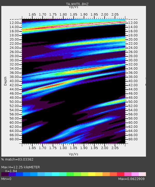
| Estimated Moho Depth: |
12.25 km |
| Estimated Crust Vp/Vs: |
1.94 |
| Assumed Crust Vp: |
6.347 km/s |
| Estimated Crust Vs: |
3.272 km/s |
| Estimated Crust Poisson's Ratio: |
0.32 |
|
| Radial Match: |
83.03362 % |
| Radial Bump: |
400 |
| Transverse Match: |
55.760704 % |
| Transverse Bump: |
400 |
| SOD ConfigId: |
7422571 |
| Insert Time: |
2019-04-20 13:37:37.712 +0000 |
| GWidth: |
2.5 |
| Max Bumps: |
400 |
| Tol: |
0.001 |
|
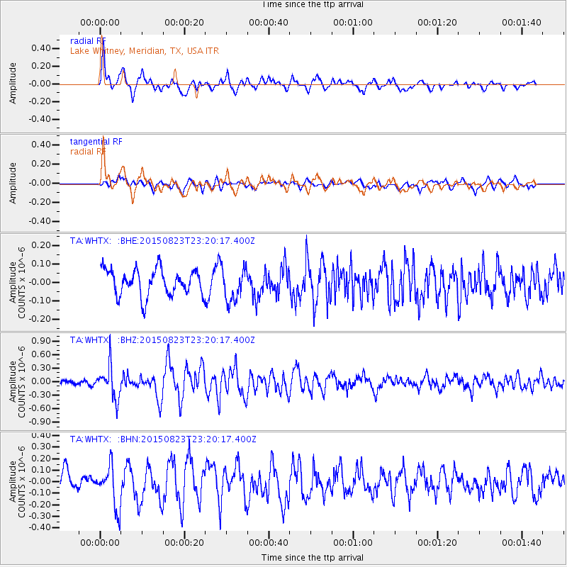
Signal To Noise
| Channel | StoN | STA | LTA |
| TA:WHTX: :BHZ:20150823T23:20:17.400Z | 7.425162 | 3.6817724E-7 | 4.958508E-8 |
| TA:WHTX: :BHN:20150823T23:20:17.400Z | 2.4853733 | 1.8419647E-7 | 7.4112194E-8 |
| TA:WHTX: :BHE:20150823T23:20:17.400Z | 1.3143436 | 9.2199485E-8 | 7.0148694E-8 |
| Arrivals |
| Ps | 1.9 SECOND |
| PpPs | 5.5 SECOND |
| PsPs/PpSs | 7.4 SECOND |


