You are here: Home > Network List > IU - Global Seismograph Network (GSN - IRIS/USGS) Stations List
> Station MAJO Matsushiro, Japan > Earthquake Result Viewer
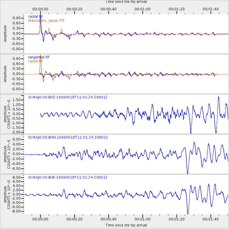
MAJO Matsushiro, Japan - Earthquake Result Viewer

| Earthquake location: |
Mindanao, Philippines |
| Earthquake latitude/longitude: |
5.5/126.6 |
| Earthquake time(UTC): |
1999/06/18 (169) 10:55:25 GMT |
| Earthquake Depth: |
33 km |
| Earthquake Magnitude: |
6.1 MB, 6.1 MS, 6.4 MW, 6.4 MW |
| Earthquake Catalog/Contributor: |
WHDF/NEIC |
|
| Network: |
IU Global Seismograph Network (GSN - IRIS/USGS) |
| Station: |
MAJO Matsushiro, Japan |
| Lat/Lon: |
36.54 N/138.21 E |
| Elevation: |
405 m |
|
| Distance: |
32.7 deg |
| Az: |
17.416 deg |
| Baz: |
201.714 deg |
| Ray Param: |
0.078510605 |
| Estimated Moho Depth: |
33.5 km |
| Estimated Crust Vp/Vs: |
1.60 |
| Assumed Crust Vp: |
6.461 km/s |
| Estimated Crust Vs: |
4.038 km/s |
| Estimated Crust Poisson's Ratio: |
0.18 |
|
| Radial Match: |
89.54842 % |
| Radial Bump: |
267 |
| Transverse Match: |
54.123856 % |
| Transverse Bump: |
400 |
| SOD ConfigId: |
4480 |
| Insert Time: |
2010-03-04 16:03:36.216 +0000 |
| GWidth: |
2.5 |
| Max Bumps: |
400 |
| Tol: |
0.001 |
|
Signal To Noise
| Channel | StoN | STA | LTA |
| IU:MAJO:00:BHN:19990618T11:01:24.39801Z | 2.851554 | 2.999178E-7 | 1.05176966E-7 |
| IU:MAJO:00:BHE:19990618T11:01:24.39801Z | 1.2175182 | 2.8307443E-7 | 2.3250118E-7 |
| IU:MAJO:00:BHZ:19990618T11:01:24.39801Z | 1.3893147 | 1.9570318E-7 | 1.4086311E-7 |
| Arrivals |
| Ps | 3.4 SECOND |
| PpPs | 12 SECOND |
| PsPs/PpSs | 16 SECOND |


