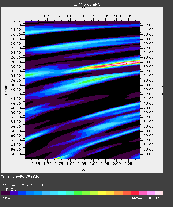
MAJO Matsushiro, Japan - Earthquake Result Viewer
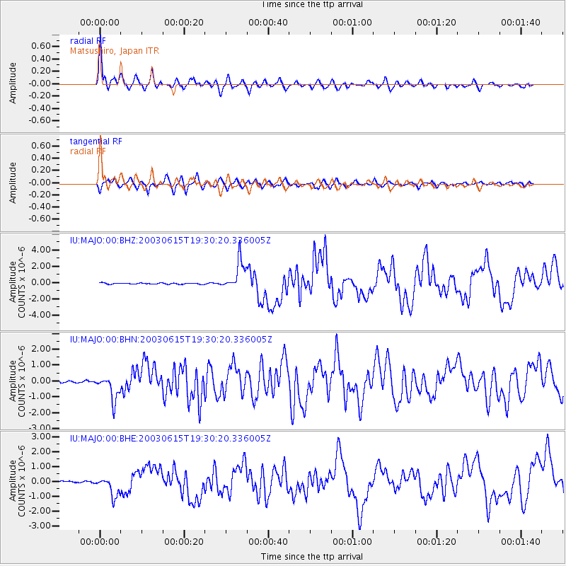
Earthquake location: Rat Islands, Aleutian Islands
Earthquake latitude/longitude: 51.6/176.9
Earthquake time(UTC): 2003/06/15 (166) 19:24:33 GMT
Earthquake Depth: 20 km
Earthquake Magnitude: 6.0 MB, 6.4 MS, 6.5 MW, 6.5 MW
Earthquake Catalog/Contributor: WHDF/NEIC
Network: IU Global Seismograph Network (GSN - IRIS/USGS)
Station: MAJO Matsushiro, Japan
Lat/Lon: 36.54 N/138.21 E
Elevation: 405 m
Distance: 31.2 deg
Az: 256.526 deg
Baz: 48.934 deg
Ray Param: 0.07912095
Estimated Moho Depth: 28.25 km
Estimated Crust Vp/Vs: 2.04
Assumed Crust Vp: 6.461 km/s
Estimated Crust Vs: 3.167 km/s
Estimated Crust Poisson's Ratio: 0.34
Radial Match: 90.393326 %
Radial Bump: 400
Transverse Match: 78.87146 %
Transverse Bump: 400
SOD ConfigId: 4714
Insert Time: 2010-03-04 16:03:39.486 +0000
GWidth: 2.5
Max Bumps: 400
Tol: 0.001

Signal To Noise

ChannelStoNSTALTA
IU:MAJO:00:BHN:20030615T19:30:20.336005Z13.3726168.116734E-76.069668E-8
IU:MAJO:00:BHE:20030615T19:30:20.336005Z11.0230626.752003E-76.125343E-8
IU:MAJO:00:BHZ:20030615T19:30:20.336005Z26.9862081.8661027E-66.915024E-8
Arrivals
Ps4.9 SECOND
PpPs12 SECOND
PsPs/PpSs17 SECOND