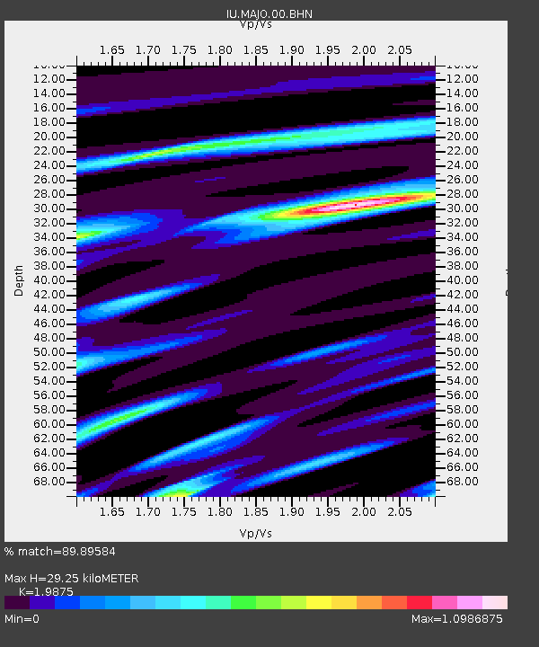
MAJO Matsushiro, Japan - Earthquake Result Viewer

Earthquake location: Rat Islands, Aleutian Islands
Earthquake latitude/longitude: 51.3/178.0
Earthquake time(UTC): 2003/03/17 (076) 16:36:17 GMT
Earthquake Depth: 33 km
Earthquake Magnitude: 5.9 MB, 6.7 MS, 7.0 MW, 7.0 MW
Earthquake Catalog/Contributor: WHDF/NEIC
Network: IU Global Seismograph Network (GSN - IRIS/USGS)
Station: MAJO Matsushiro, Japan
Lat/Lon: 36.54 N/138.21 E
Elevation: 405 m
Distance: 31.8 deg
Az: 258.032 deg
Baz: 49.737 deg
Ray Param: 0.07888278
Estimated Moho Depth: 29.25 km
Estimated Crust Vp/Vs: 1.99
Assumed Crust Vp: 6.461 km/s
Estimated Crust Vs: 3.251 km/s
Estimated Crust Poisson's Ratio: 0.33
Radial Match: 89.89584 %
Radial Bump: 400
Transverse Match: 77.378555 %
Transverse Bump: 400
SOD ConfigId: 4714
Insert Time: 2010-03-04 16:03:42.764 +0000
GWidth: 2.5
Max Bumps: 400
Tol: 0.001

Signal To Noise

ChannelStoNSTALTA
IU:MAJO:00:BHN:20030317T16:42:08.273013Z11.5170361.8577978E-61.6130866E-7
IU:MAJO:00:BHE:20030317T16:42:08.273013Z9.6360221.7561282E-61.822462E-7
IU:MAJO:00:BHZ:20030317T16:42:08.273013Z32.095624.6894634E-61.4610913E-7
Arrivals
Ps4.8 SECOND
PpPs13 SECOND
PsPs/PpSs17 SECOND