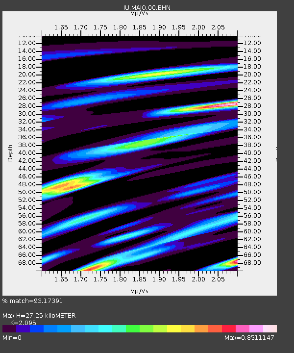
MAJO Matsushiro, Japan - Earthquake Result Viewer

Earthquake location: Unimak Island Region, Alaska
Earthquake latitude/longitude: 53.6/-164.6
Earthquake time(UTC): 2003/02/19 (050) 03:32:36 GMT
Earthquake Depth: 19 km
Earthquake Magnitude: 5.8 MB, 6.6 MS, 6.6 MW, 6.6 MW
Earthquake Catalog/Contributor: WHDF/NEIC
Network: IU Global Seismograph Network (GSN - IRIS/USGS)
Station: MAJO Matsushiro, Japan
Lat/Lon: 36.54 N/138.21 E
Elevation: 405 m
Distance: 42.6 deg
Az: 270.167 deg
Baz: 47.671 deg
Ray Param: 0.07307444
Estimated Moho Depth: 27.25 km
Estimated Crust Vp/Vs: 2.10
Assumed Crust Vp: 6.461 km/s
Estimated Crust Vs: 3.084 km/s
Estimated Crust Poisson's Ratio: 0.35
Radial Match: 93.17391 %
Radial Bump: 366
Transverse Match: 84.893555 %
Transverse Bump: 400
SOD ConfigId: 4714
Insert Time: 2010-03-04 16:03:44.372 +0000
GWidth: 2.5
Max Bumps: 400
Tol: 0.001

Signal To Noise

ChannelStoNSTALTA
IU:MAJO:00:BHN:20030219T03:40:00.172012Z10.7758221.3471276E-61.2501391E-7
IU:MAJO:00:BHE:20030219T03:40:00.172012Z9.6942561.1589672E-61.1955194E-7
IU:MAJO:00:BHZ:20030219T03:40:00.172012Z24.6852253.3129143E-61.3420637E-7
Arrivals
Ps4.9 SECOND
PpPs12 SECOND
PsPs/PpSs17 SECOND