You are here: Home > Network List > IU - Global Seismograph Network (GSN - IRIS/USGS) Stations List
> Station MAJO Matsushiro, Japan > Earthquake Result Viewer
MAJO Matsushiro, Japan - Earthquake Result Viewer
| Earthquake location: |
Seram, Indonesia |
| Earthquake latitude/longitude: |
-3.2/127.5 |
| Earthquake time(UTC): |
2003/03/30 (089) 18:13:34 GMT |
| Earthquake Depth: |
33 km |
| Earthquake Magnitude: |
5.8 MB, 6.0 MS, 6.2 MW, 6.2 MW |
| Earthquake Catalog/Contributor: |
WHDF/NEIC |
|
| Network: |
IU Global Seismograph Network (GSN - IRIS/USGS) |
| Station: |
MAJO Matsushiro, Japan |
| Lat/Lon: |
36.54 N/138.21 E |
| Elevation: |
405 m |
|
| Distance: |
40.7 deg |
| Az: |
13.201 deg |
| Baz: |
196.448 deg |
| Ray Param: |
0.0741571 |
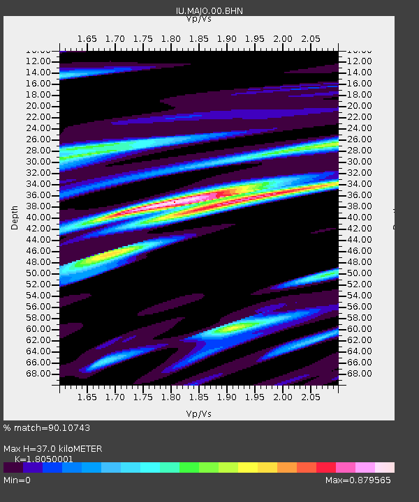
| Estimated Moho Depth: |
37.0 km |
| Estimated Crust Vp/Vs: |
1.81 |
| Assumed Crust Vp: |
6.461 km/s |
| Estimated Crust Vs: |
3.58 km/s |
| Estimated Crust Poisson's Ratio: |
0.28 |
|
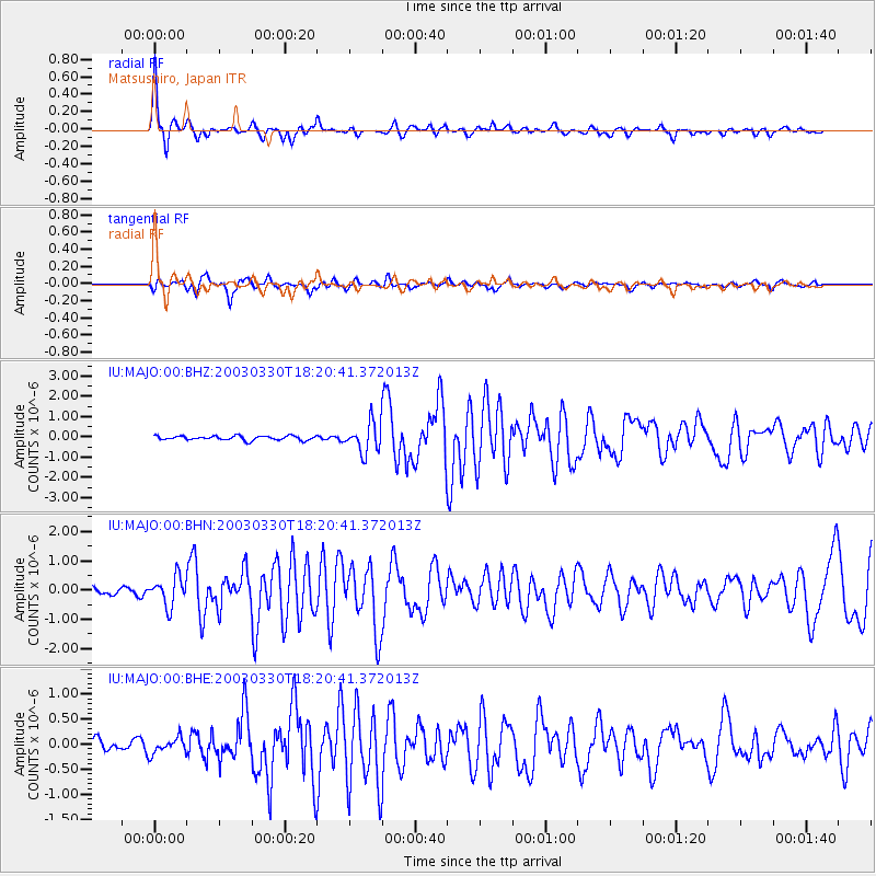
| Radial Match: |
90.10743 % |
| Radial Bump: |
346 |
| Transverse Match: |
81.86716 % |
| Transverse Bump: |
400 |
| SOD ConfigId: |
4714 |
| Insert Time: |
2010-03-04 16:03:53.095 +0000 |
| GWidth: |
2.5 |
| Max Bumps: |
400 |
| Tol: |
0.001 |
|
Signal To Noise
| Channel | StoN | STA | LTA |
| IU:MAJO:00:BHN:20030330T18:20:41.372013Z | 5.055139 | 4.9527716E-7 | 9.7974976E-8 |
| IU:MAJO:00:BHE:20030330T18:20:41.372013Z | 1.5596752 | 1.5993736E-7 | 1.02545286E-7 |
| IU:MAJO:00:BHZ:20030330T18:20:41.372013Z | 6.945903 | 7.250812E-7 | 1.0438976E-7 |
| Arrivals |
| Ps | 4.9 SECOND |
| PpPs | 15 SECOND |
| PsPs/PpSs | 20 SECOND |


