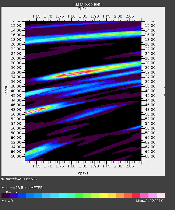
MAJO Matsushiro, Japan - Earthquake Result Viewer

Earthquake location: Southeast Of Loyalty Islands
Earthquake latitude/longitude: -22.0/170.3
Earthquake time(UTC): 2004/05/07 (128) 01:26:42 GMT
Earthquake Depth: 14 km
Earthquake Magnitude: 5.7 MB, 6.2 MS, 6.3 MW, 6.2 MW
Earthquake Catalog/Contributor: WHDF/NEIC
Network: IU Global Seismograph Network (GSN - IRIS/USGS)
Station: MAJO Matsushiro, Japan
Lat/Lon: 36.54 N/138.21 E
Elevation: 405 m
Distance: 65.6 deg
Az: 332.004 deg
Baz: 147.248 deg
Ray Param: 0.058140587
Estimated Moho Depth: 48.5 km
Estimated Crust Vp/Vs: 1.63
Assumed Crust Vp: 6.461 km/s
Estimated Crust Vs: 3.964 km/s
Estimated Crust Poisson's Ratio: 0.20
Radial Match: 90.65537 %
Radial Bump: 400
Transverse Match: 83.66088 %
Transverse Bump: 400
SOD ConfigId: 2459
Insert Time: 2010-03-04 16:04:07.328 +0000
GWidth: 2.5
Max Bumps: 400
Tol: 0.001

Signal To Noise

ChannelStoNSTALTA
IU:MAJO:00:BHN:20040507T01:36:54.522021Z4.83889774.2364286E-78.754945E-8
IU:MAJO:00:BHE:20040507T01:36:54.522021Z3.39607142.3219508E-76.837167E-8
IU:MAJO:00:BHZ:20040507T01:36:54.522021Z14.826691.2310456E-68.302903E-8
Arrivals
Ps4.9 SECOND
PpPs19 SECOND
PsPs/PpSs24 SECOND