You are here: Home > Network List > TA - USArray Transportable Network (new EarthScope stations) Stations List
> Station MSTX Muleshoe, TX, USA > Earthquake Result Viewer
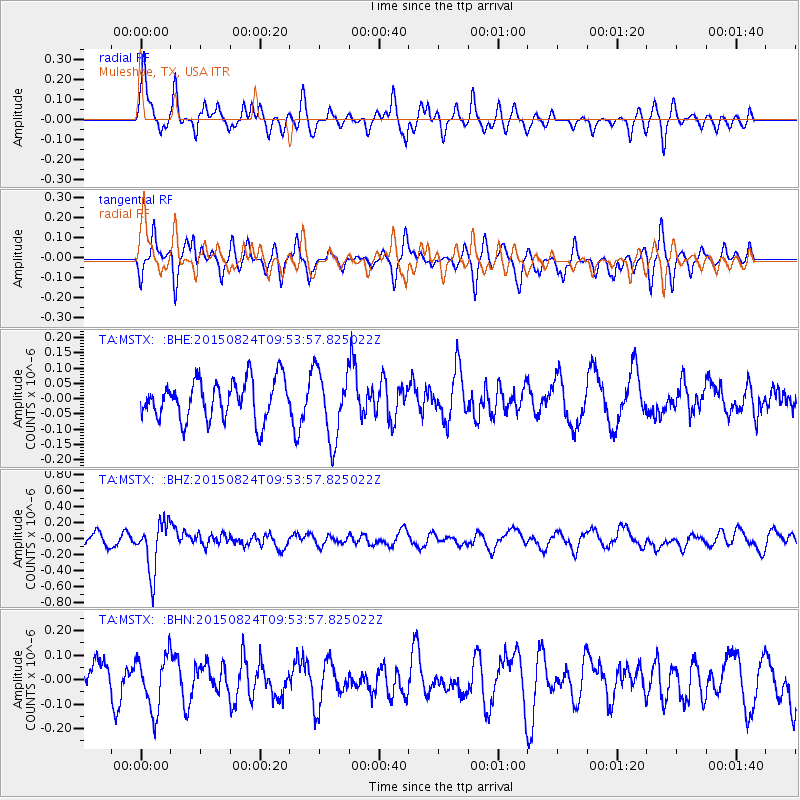
MSTX Muleshoe, TX, USA - Earthquake Result Viewer
*The percent match for this event was below the threshold and hence no stack was calculated.
| Earthquake location: |
Kermadec Islands Region |
| Earthquake latitude/longitude: |
-30.6/-179.1 |
| Earthquake time(UTC): |
2015/08/24 (236) 09:41:25 GMT |
| Earthquake Depth: |
224 km |
| Earthquake Magnitude: |
6.0 MW |
| Earthquake Catalog/Contributor: |
ISC/ISC |
|
| Network: |
TA USArray Transportable Network (new EarthScope stations) |
| Station: |
MSTX Muleshoe, TX, USA |
| Lat/Lon: |
33.97 N/102.77 W |
| Elevation: |
1167 m |
|
| Distance: |
96.5 deg |
| Az: |
54.36 deg |
| Baz: |
237.431 deg |
| Ray Param: |
$rayparam |
*The percent match for this event was below the threshold and hence was not used in the summary stack. |
|
| Radial Match: |
65.59935 % |
| Radial Bump: |
315 |
| Transverse Match: |
61.455288 % |
| Transverse Bump: |
292 |
| SOD ConfigId: |
7422571 |
| Insert Time: |
2019-04-20 13:46:38.506 +0000 |
| GWidth: |
2.5 |
| Max Bumps: |
400 |
| Tol: |
0.001 |
|
Signal To Noise
| Channel | StoN | STA | LTA |
| TA:MSTX: :BHZ:20150824T09:53:57.825022Z | 4.1740193 | 3.1266944E-7 | 7.490848E-8 |
| TA:MSTX: :BHN:20150824T09:53:57.825022Z | 1.2605428 | 1.136506E-7 | 9.016006E-8 |
| TA:MSTX: :BHE:20150824T09:53:57.825022Z | 1.745176 | 1.1282948E-7 | 6.4652205E-8 |
| Arrivals |
| Ps | |
| PpPs | |
| PsPs/PpSs | |


