You are here: Home > Network List > IU - Global Seismograph Network (GSN - IRIS/USGS) Stations List
> Station MAJO Matsushiro, Japan > Earthquake Result Viewer
MAJO Matsushiro, Japan - Earthquake Result Viewer
| Earthquake location: |
Irian Jaya, Indonesia |
| Earthquake latitude/longitude: |
-3.7/140.1 |
| Earthquake time(UTC): |
2004/04/11 (102) 07:37:29 GMT |
| Earthquake Depth: |
20 km |
| Earthquake Magnitude: |
5.4 MB, 6.0 MS, 6.2 MW, 6.0 MW |
| Earthquake Catalog/Contributor: |
WHDF/NEIC |
|
| Network: |
IU Global Seismograph Network (GSN - IRIS/USGS) |
| Station: |
MAJO Matsushiro, Japan |
| Lat/Lon: |
36.54 N/138.21 E |
| Elevation: |
405 m |
|
| Distance: |
40.1 deg |
| Az: |
357.657 deg |
| Baz: |
177.097 deg |
| Ray Param: |
0.07456067 |
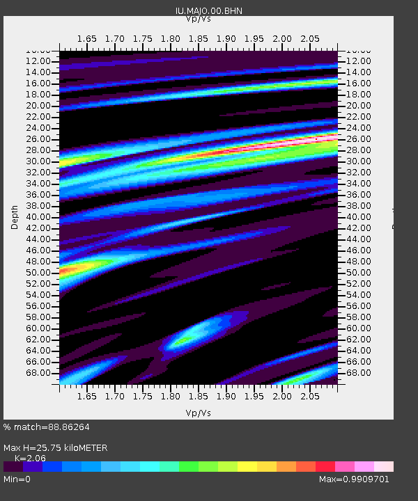
| Estimated Moho Depth: |
25.75 km |
| Estimated Crust Vp/Vs: |
2.06 |
| Assumed Crust Vp: |
6.461 km/s |
| Estimated Crust Vs: |
3.137 km/s |
| Estimated Crust Poisson's Ratio: |
0.35 |
|
| Radial Match: |
88.86264 % |
| Radial Bump: |
400 |
| Transverse Match: |
80.16207 % |
| Transverse Bump: |
400 |
| SOD ConfigId: |
2459 |
| Insert Time: |
2010-03-04 16:04:16.949 +0000 |
| GWidth: |
2.5 |
| Max Bumps: |
400 |
| Tol: |
0.001 |
|

Signal To Noise
| Channel | StoN | STA | LTA |
| IU:MAJO:00:BHN:20040411T07:44:33.273004Z | 6.694003 | 4.1130863E-7 | 6.144435E-8 |
| IU:MAJO:00:BHE:20040411T07:44:33.273004Z | 1.7223883 | 1.4522999E-7 | 8.431897E-8 |
| IU:MAJO:00:BHZ:20040411T07:44:33.273004Z | 18.290369 | 9.068441E-7 | 4.9580414E-8 |
| Arrivals |
| Ps | 4.5 SECOND |
| PpPs | 11 SECOND |
| PsPs/PpSs | 16 SECOND |


