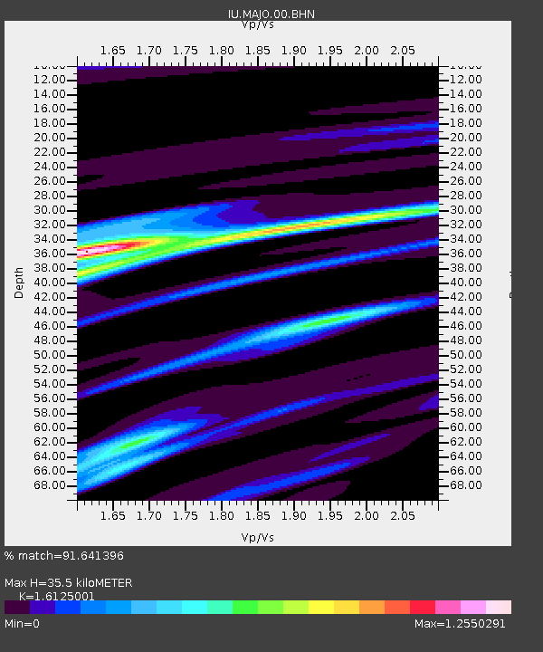
MAJO Matsushiro, Japan - Earthquake Result Viewer
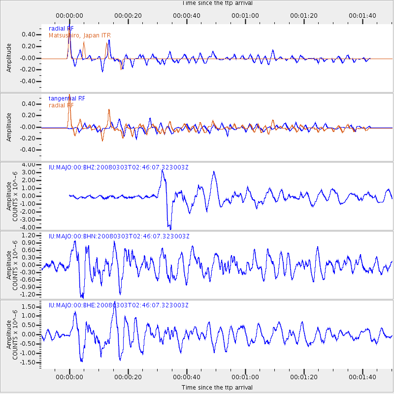
Earthquake location: Southern Sumatra, Indonesia
Earthquake latitude/longitude: -2.2/99.8
Earthquake time(UTC): 2008/03/03 (063) 02:37:27 GMT
Earthquake Depth: 25 km
Earthquake Magnitude: 5.8 MB, 6.1 MS, 6.1 MW, 6.1 MW
Earthquake Catalog/Contributor: WHDF/NEIC
Network: IU Global Seismograph Network (GSN - IRIS/USGS)
Station: MAJO Matsushiro, Japan
Lat/Lon: 36.54 N/138.21 E
Elevation: 405 m
Distance: 52.5 deg
Az: 39.057 deg
Baz: 231.43 deg
Ray Param: 0.06666547
Estimated Moho Depth: 35.5 km
Estimated Crust Vp/Vs: 1.61
Assumed Crust Vp: 6.461 km/s
Estimated Crust Vs: 4.007 km/s
Estimated Crust Poisson's Ratio: 0.19
Radial Match: 91.641396 %
Radial Bump: 400
Transverse Match: 82.76992 %
Transverse Bump: 400
SOD ConfigId: 2564
Insert Time: 2010-03-04 16:04:36.164 +0000
GWidth: 2.5
Max Bumps: 400
Tol: 0.001

Signal To Noise

ChannelStoNSTALTA
IU:MAJO:00:BHN:20080303T02:46:07.323003Z6.9272727.574687E-71.0934588E-7
IU:MAJO:00:BHE:20080303T02:46:07.323003Z6.89191258.008643E-71.162035E-7
IU:MAJO:00:BHZ:20080303T02:46:07.323003Z19.54222.3825385E-61.2191762E-7
Arrivals
Ps3.6 SECOND
PpPs13 SECOND
PsPs/PpSs17 SECOND