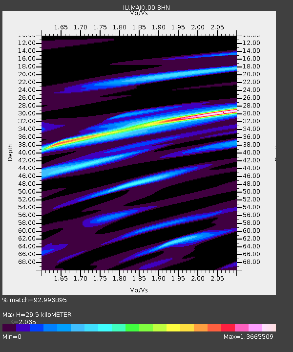
MAJO Matsushiro, Japan - Earthquake Result Viewer
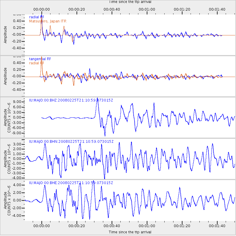
Earthquake location: Southern Sumatra, Indonesia
Earthquake latitude/longitude: -2.2/99.8
Earthquake time(UTC): 2008/02/25 (056) 21:02:18 GMT
Earthquake Depth: 25 km
Earthquake Magnitude: 6.2 MB, 6.6 MS, 6.6 MW, 6.5 MW
Earthquake Catalog/Contributor: WHDF/NEIC
Network: IU Global Seismograph Network (GSN - IRIS/USGS)
Station: MAJO Matsushiro, Japan
Lat/Lon: 36.54 N/138.21 E
Elevation: 405 m
Distance: 52.6 deg
Az: 39.035 deg
Baz: 231.393 deg
Ray Param: 0.066627376
Estimated Moho Depth: 29.5 km
Estimated Crust Vp/Vs: 2.07
Assumed Crust Vp: 6.461 km/s
Estimated Crust Vs: 3.129 km/s
Estimated Crust Poisson's Ratio: 0.35
Radial Match: 92.996895 %
Radial Bump: 400
Transverse Match: 84.44134 %
Transverse Bump: 400
SOD ConfigId: 2564
Insert Time: 2010-03-04 16:04:37.313 +0000
GWidth: 2.5
Max Bumps: 400
Tol: 0.001

Signal To Noise

ChannelStoNSTALTA
IU:MAJO:00:BHN:20080225T21:10:59.073015Z3.30090481.4608306E-64.425546E-7
IU:MAJO:00:BHE:20080225T21:10:59.073015Z10.4369011.8640168E-61.785987E-7
IU:MAJO:00:BHZ:20080225T21:10:59.073015Z19.1773645.0993754E-62.6590595E-7
Arrivals
Ps5.1 SECOND
PpPs13 SECOND
PsPs/PpSs18 SECOND