You are here: Home > Network List > WY - Yellowstone Wyoming Seismic Network Stations List
> Station YHH Holmes Hill, YNP, WY, USA > Earthquake Result Viewer
YHH Holmes Hill, YNP, WY, USA - Earthquake Result Viewer
*The percent match for this event was below the threshold and hence no stack was calculated.
| Earthquake location: |
Kermadec Islands Region |
| Earthquake latitude/longitude: |
-30.6/-179.1 |
| Earthquake time(UTC): |
2015/08/24 (236) 09:41:25 GMT |
| Earthquake Depth: |
224 km |
| Earthquake Magnitude: |
6.0 MW |
| Earthquake Catalog/Contributor: |
ISC/ISC |
|
| Network: |
WY Yellowstone Wyoming Seismic Network |
| Station: |
YHH Holmes Hill, YNP, WY, USA |
| Lat/Lon: |
44.79 N/110.85 W |
| Elevation: |
2717 m |
|
| Distance: |
97.4 deg |
| Az: |
41.829 deg |
| Baz: |
233.817 deg |
| Ray Param: |
$rayparam |
*The percent match for this event was below the threshold and hence was not used in the summary stack. |
|
| Radial Match: |
55.44648 % |
| Radial Bump: |
400 |
| Transverse Match: |
58.335213 % |
| Transverse Bump: |
400 |
| SOD ConfigId: |
7422571 |
| Insert Time: |
2019-04-20 13:48:29.167 +0000 |
| GWidth: |
2.5 |
| Max Bumps: |
400 |
| Tol: |
0.001 |
|
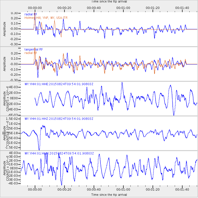
Signal To Noise
| Channel | StoN | STA | LTA |
| WY:YHH:01:HHZ:20150824T09:54:01.90803Z | 5.6775436 | 7.5681355E-9 | 1.3329947E-9 |
| WY:YHH:01:HHN:20150824T09:54:01.90803Z | 0.9978084 | 1.340932E-9 | 1.3438772E-9 |
| WY:YHH:01:HHE:20150824T09:54:01.90803Z | 0.9168065 | 1.5046708E-9 | 1.6412087E-9 |
| Arrivals |
| Ps | |
| PpPs | |
| PsPs/PpSs | |


