You are here: Home > Network List > IU - Global Seismograph Network (GSN - IRIS/USGS) Stations List
> Station MAJO Matsushiro, Japan > Earthquake Result Viewer
MAJO Matsushiro, Japan - Earthquake Result Viewer
| Earthquake location: |
Southwest Of Sumatra, Indonesia |
| Earthquake latitude/longitude: |
-2.2/92.3 |
| Earthquake time(UTC): |
1990/10/15 (288) 01:35:44 GMT |
| Earthquake Depth: |
34 km |
| Earthquake Magnitude: |
5.9 MB, 6.5 MS |
| Earthquake Catalog/Contributor: |
WHDF/NEIC |
|
| Network: |
IU Global Seismograph Network (GSN - IRIS/USGS) |
| Station: |
MAJO Matsushiro, Japan |
| Lat/Lon: |
36.54 N/138.21 E |
| Elevation: |
405 m |
|
| Distance: |
57.5 deg |
| Az: |
43.31 deg |
| Baz: |
238.336 deg |
| Ray Param: |
0.063387424 |
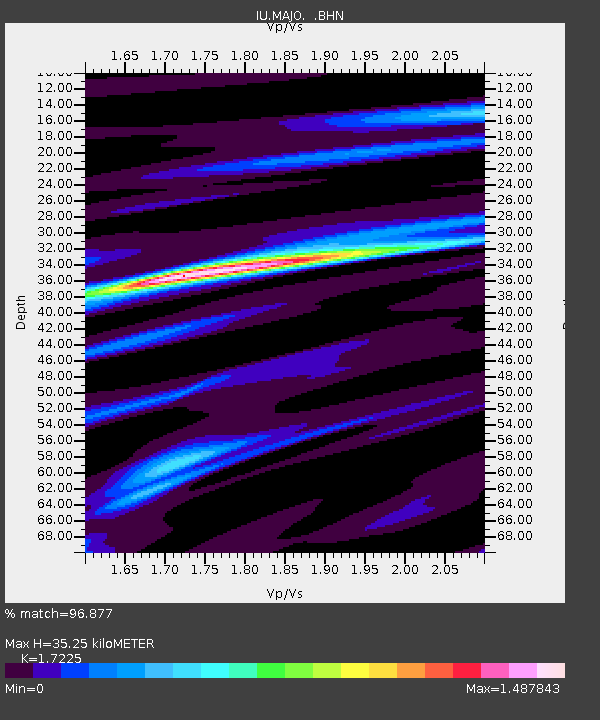
| Estimated Moho Depth: |
35.25 km |
| Estimated Crust Vp/Vs: |
1.72 |
| Assumed Crust Vp: |
6.461 km/s |
| Estimated Crust Vs: |
3.751 km/s |
| Estimated Crust Poisson's Ratio: |
0.25 |
|
| Radial Match: |
96.877 % |
| Radial Bump: |
359 |
| Transverse Match: |
93.62157 % |
| Transverse Bump: |
400 |
| SOD ConfigId: |
17000 |
| Insert Time: |
2010-03-04 16:04:54.602 +0000 |
| GWidth: |
2.5 |
| Max Bumps: |
400 |
| Tol: |
0.001 |
|

Signal To Noise
| Channel | StoN | STA | LTA |
| IU:MAJO: :BHN:19901015T01:44:59.905017Z | 1.9430403 | 1.951862E-7 | 1.0045402E-7 |
| IU:MAJO: :BHE:19901015T01:44:59.905017Z | 1.7073857 | 1.4189159E-7 | 8.3104595E-8 |
| IU:MAJO: :BHZ:19901015T01:44:59.905017Z | 4.098287 | 3.7376157E-7 | 9.119945E-8 |
| Arrivals |
| Ps | 4.2 SECOND |
| PpPs | 14 SECOND |
| PsPs/PpSs | 18 SECOND |


