You are here: Home > Network List > IU - Global Seismograph Network (GSN - IRIS/USGS) Stations List
> Station MAJO Matsushiro, Japan > Earthquake Result Viewer
MAJO Matsushiro, Japan - Earthquake Result Viewer
| Earthquake location: |
Afghanistan-Tajikistan Bord Reg. |
| Earthquake latitude/longitude: |
36.4/71.1 |
| Earthquake time(UTC): |
2005/12/12 (346) 21:47:46 GMT |
| Earthquake Depth: |
225 km |
| Earthquake Magnitude: |
6.0 MB, 6.5 MW, 6.5 MW |
| Earthquake Catalog/Contributor: |
WHDF/NEIC |
|
| Network: |
IU Global Seismograph Network (GSN - IRIS/USGS) |
| Station: |
MAJO Matsushiro, Japan |
| Lat/Lon: |
36.54 N/138.21 E |
| Elevation: |
405 m |
|
| Distance: |
52.9 deg |
| Az: |
68.403 deg |
| Baz: |
291.251 deg |
| Ray Param: |
0.06561712 |
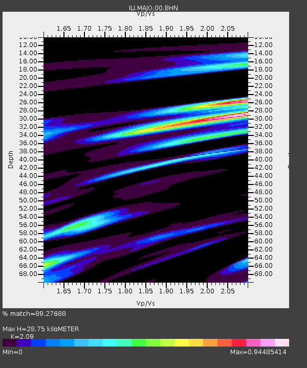
| Estimated Moho Depth: |
28.75 km |
| Estimated Crust Vp/Vs: |
2.09 |
| Assumed Crust Vp: |
6.461 km/s |
| Estimated Crust Vs: |
3.092 km/s |
| Estimated Crust Poisson's Ratio: |
0.35 |
|
| Radial Match: |
89.27688 % |
| Radial Bump: |
325 |
| Transverse Match: |
74.3163 % |
| Transverse Bump: |
400 |
| SOD ConfigId: |
2422 |
| Insert Time: |
2010-03-04 16:05:25.573 +0000 |
| GWidth: |
2.5 |
| Max Bumps: |
400 |
| Tol: |
0.001 |
|
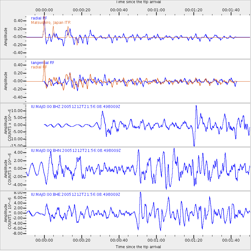
Signal To Noise
| Channel | StoN | STA | LTA |
| IU:MAJO:00:BHN:20051212T21:56:08.498009Z | 2.3687994 | 2.2919098E-6 | 9.675407E-7 |
| IU:MAJO:00:BHE:20051212T21:56:08.498009Z | 2.246802 | 1.7103383E-6 | 7.6123234E-7 |
| IU:MAJO:00:BHZ:20051212T21:56:08.498009Z | 7.457895 | 4.9751497E-6 | 6.6709845E-7 |
| Arrivals |
| Ps | 5.1 SECOND |
| PpPs | 13 SECOND |
| PsPs/PpSs | 18 SECOND |


