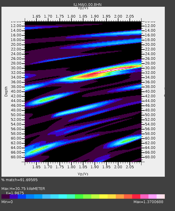
MAJO Matsushiro, Japan - Earthquake Result Viewer
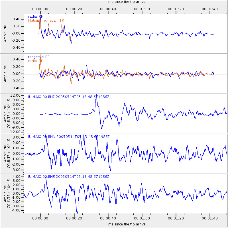
Earthquake location: Northern Sumatra, Indonesia
Earthquake latitude/longitude: 0.6/98.5
Earthquake time(UTC): 2005/05/14 (134) 05:05:18 GMT
Earthquake Depth: 34 km
Earthquake Magnitude: 6.4 MB, 6.8 MS, 6.8 MW, 6.8 MW
Earthquake Catalog/Contributor: WHDF/NEIC
Network: IU Global Seismograph Network (GSN - IRIS/USGS)
Station: MAJO Matsushiro, Japan
Lat/Lon: 36.54 N/138.21 E
Elevation: 405 m
Distance: 51.3 deg
Az: 41.282 deg
Baz: 235.007 deg
Ray Param: 0.067435324
Estimated Moho Depth: 30.75 km
Estimated Crust Vp/Vs: 1.97
Assumed Crust Vp: 6.461 km/s
Estimated Crust Vs: 3.284 km/s
Estimated Crust Poisson's Ratio: 0.33
Radial Match: 91.69595 %
Radial Bump: 400
Transverse Match: 84.818 %
Transverse Bump: 400
SOD ConfigId: 2455
Insert Time: 2010-03-04 16:05:51.720 +0000
GWidth: 2.5
Max Bumps: 400
Tol: 0.001

Signal To Noise

ChannelStoNSTALTA
IU:MAJO:00:BHN:20050514T05:13:48.671986Z9.1032971.534058E-61.6851673E-7
IU:MAJO:00:BHE:20050514T05:13:48.671986Z5.5297441.738368E-63.1436682E-7
IU:MAJO:00:BHZ:20050514T05:13:48.671986Z25.5332575.4262514E-62.1251701E-7
Arrivals
Ps4.8 SECOND
PpPs13 SECOND
PsPs/PpSs18 SECOND