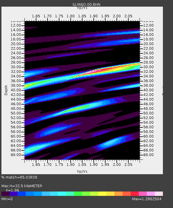
MAJO Matsushiro, Japan - Earthquake Result Viewer
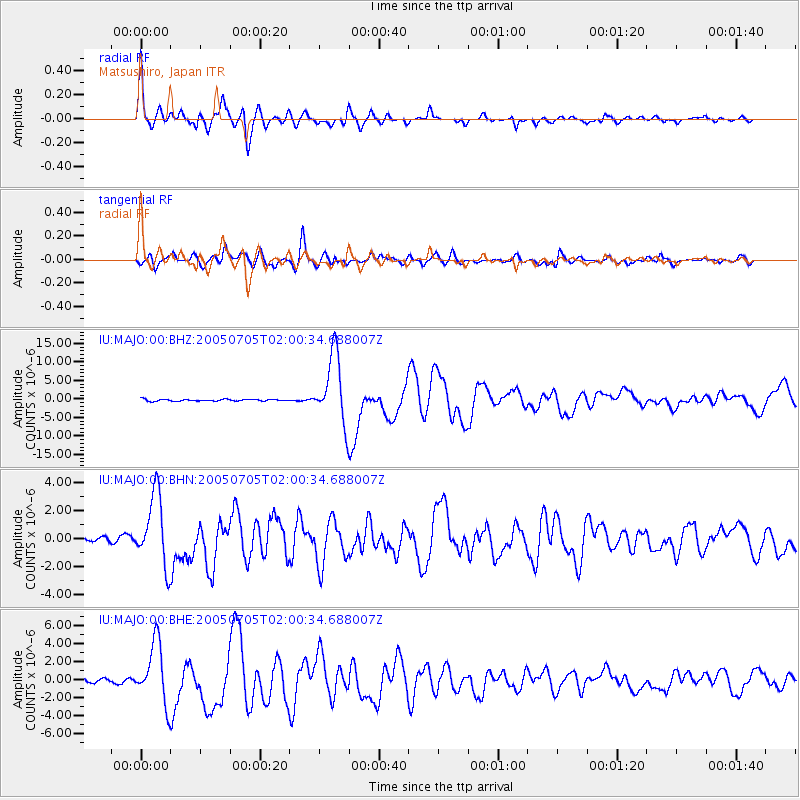
Earthquake location: Northern Sumatra, Indonesia
Earthquake latitude/longitude: 1.8/97.1
Earthquake time(UTC): 2005/07/05 (186) 01:52:02 GMT
Earthquake Depth: 21 km
Earthquake Magnitude: 6.2 MB, 6.8 MS, 6.7 MW, 6.6 MW
Earthquake Catalog/Contributor: WHDF/NEIC
Network: IU Global Seismograph Network (GSN - IRIS/USGS)
Station: MAJO Matsushiro, Japan
Lat/Lon: 36.54 N/138.21 E
Elevation: 405 m
Distance: 51.3 deg
Az: 42.729 deg
Baz: 237.367 deg
Ray Param: 0.06746372
Estimated Moho Depth: 32.5 km
Estimated Crust Vp/Vs: 1.86
Assumed Crust Vp: 6.461 km/s
Estimated Crust Vs: 3.474 km/s
Estimated Crust Poisson's Ratio: 0.30
Radial Match: 95.03928 %
Radial Bump: 400
Transverse Match: 91.660194 %
Transverse Bump: 400
SOD ConfigId: 2475
Insert Time: 2010-03-04 16:05:55.411 +0000
GWidth: 2.5
Max Bumps: 400
Tol: 0.001

Signal To Noise

ChannelStoNSTALTA
IU:MAJO:00:BHN:20050705T02:00:34.688007Z10.6954642.57094E-62.403767E-7
IU:MAJO:00:BHE:20050705T02:00:34.688007Z17.8917313.3718698E-61.8845968E-7
IU:MAJO:00:BHZ:20050705T02:00:34.688007Z39.3006329.283321E-62.3621301E-7
Arrivals
Ps4.6 SECOND
PpPs14 SECOND
PsPs/PpSs18 SECOND