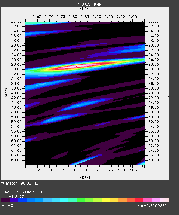
GSC Goldstone, California, USA - Earthquake Result Viewer
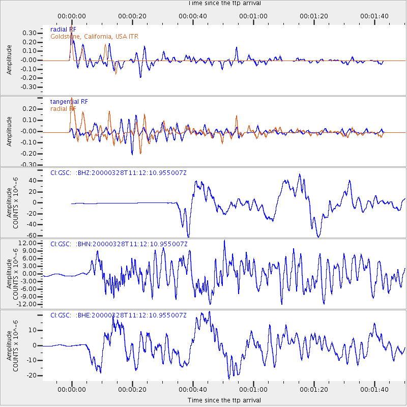
Earthquake location: Volcano Islands, Japan Region
Earthquake latitude/longitude: 22.3/143.7
Earthquake time(UTC): 2000/03/28 (088) 11:00:22 GMT
Earthquake Depth: 126 km
Earthquake Magnitude: 6.8 MB, 7.6 MS, 7.6 MW, 7.6 MW
Earthquake Catalog/Contributor: WHDF/NEIC
Network: CI Caltech Regional Seismic Network
Station: GSC Goldstone, California, USA
Lat/Lon: 35.30 N/116.81 W
Elevation: 954 m
Distance: 84.7 deg
Az: 54.126 deg
Baz: 293.478 deg
Ray Param: 0.045031726
Estimated Moho Depth: 28.5 km
Estimated Crust Vp/Vs: 1.81
Assumed Crust Vp: 6.276 km/s
Estimated Crust Vs: 3.463 km/s
Estimated Crust Poisson's Ratio: 0.28
Radial Match: 96.01741 %
Radial Bump: 400
Transverse Match: 86.69342 %
Transverse Bump: 400
SOD ConfigId: 3744
Insert Time: 2010-02-25 23:40:04.579 +0000
GWidth: 2.5
Max Bumps: 400
Tol: 0.001

Signal To Noise

ChannelStoNSTALTA
CI:GSC: :BHN:20000328T11:12:10.955007Z1.49120454.625188E-73.1016458E-7
CI:GSC: :BHE:20000328T11:12:10.955007Z3.08566285.9322974E-71.9225358E-7
CI:GSC: :BHZ:20000328T11:12:10.955007Z2.1697069.3058674E-74.288999E-7
Arrivals
Ps3.8 SECOND
PpPs12 SECOND
PsPs/PpSs16 SECOND