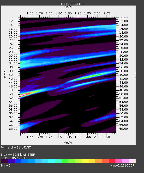
MAJO Matsushiro, Japan - Earthquake Result Viewer
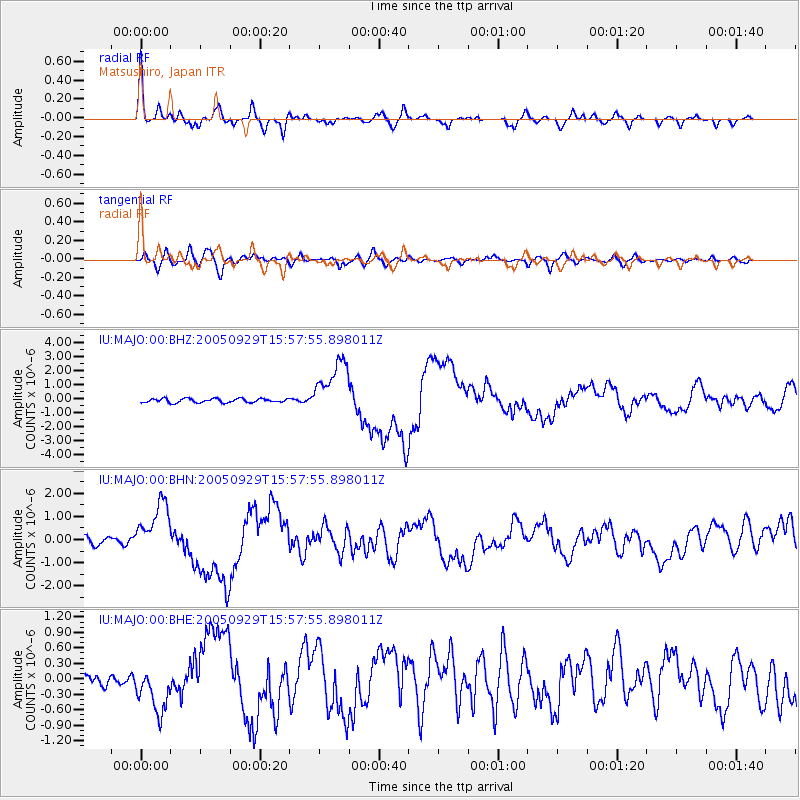
Earthquake location: New Britain Region, P.N.G.
Earthquake latitude/longitude: -5.4/151.8
Earthquake time(UTC): 2005/09/29 (272) 15:50:24 GMT
Earthquake Depth: 25 km
Earthquake Magnitude: 5.9 MB, 6.6 MS, 6.7 MW, 6.5 MW
Earthquake Catalog/Contributor: WHDF/NEIC
Network: IU Global Seismograph Network (GSN - IRIS/USGS)
Station: MAJO Matsushiro, Japan
Lat/Lon: 36.54 N/138.21 E
Elevation: 405 m
Distance: 43.7 deg
Az: 344.044 deg
Baz: 160.133 deg
Ray Param: 0.07236052
Estimated Moho Depth: 50.5 km
Estimated Crust Vp/Vs: 1.60
Assumed Crust Vp: 6.461 km/s
Estimated Crust Vs: 4.032 km/s
Estimated Crust Poisson's Ratio: 0.18
Radial Match: 91.19157 %
Radial Bump: 322
Transverse Match: 74.24048 %
Transverse Bump: 400
SOD ConfigId: 2475
Insert Time: 2010-03-04 16:06:01.698 +0000
GWidth: 2.5
Max Bumps: 400
Tol: 0.001

Signal To Noise

ChannelStoNSTALTA
IU:MAJO:00:BHN:20050929T15:57:55.898011Z5.57577131.1594102E-62.0793718E-7
IU:MAJO:00:BHE:20050929T15:57:55.898011Z2.27170094.4620563E-71.9641918E-7
IU:MAJO:00:BHZ:20050929T15:57:55.898011Z14.2859671.981897E-61.3873033E-7
Arrivals
Ps5.1 SECOND
PpPs19 SECOND
PsPs/PpSs24 SECOND