You are here: Home > Network List > TA - USArray Transportable Network (new EarthScope stations) Stations List
> Station J04D Umpqua National Forest, Toketee, OR, USA > Earthquake Result Viewer
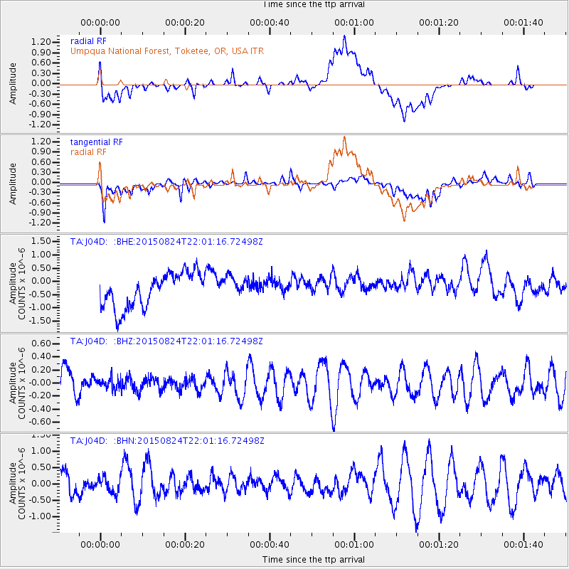
J04D Umpqua National Forest, Toketee, OR, USA - Earthquake Result Viewer
*The percent match for this event was below the threshold and hence no stack was calculated.
| Earthquake location: |
Fiji Islands Region |
| Earthquake latitude/longitude: |
-17.9/-178.5 |
| Earthquake time(UTC): |
2015/08/24 (236) 21:50:39 GMT |
| Earthquake Depth: |
590 km |
| Earthquake Magnitude: |
4.5 mb |
| Earthquake Catalog/Contributor: |
ISC/ISC |
|
| Network: |
TA USArray Transportable Network (new EarthScope stations) |
| Station: |
J04D Umpqua National Forest, Toketee, OR, USA |
| Lat/Lon: |
43.24 N/122.11 W |
| Elevation: |
1948 m |
|
| Distance: |
79.8 deg |
| Az: |
38.208 deg |
| Baz: |
233.715 deg |
| Ray Param: |
$rayparam |
*The percent match for this event was below the threshold and hence was not used in the summary stack. |
|
| Radial Match: |
52.316196 % |
| Radial Bump: |
400 |
| Transverse Match: |
65.727806 % |
| Transverse Bump: |
400 |
| SOD ConfigId: |
7422571 |
| Insert Time: |
2019-04-20 14:03:38.910 +0000 |
| GWidth: |
2.5 |
| Max Bumps: |
400 |
| Tol: |
0.001 |
|
Signal To Noise
| Channel | StoN | STA | LTA |
| TA:J04D: :BHZ:20150824T22:01:16.72498Z | 0.28733766 | 8.292456E-8 | 2.885962E-7 |
| TA:J04D: :BHN:20150824T22:01:16.72498Z | 0.67022 | 2.6690523E-7 | 3.9823522E-7 |
| TA:J04D: :BHE:20150824T22:01:16.72498Z | 0.6237048 | 3.9869195E-7 | 6.392318E-7 |
| Arrivals |
| Ps | |
| PpPs | |
| PsPs/PpSs | |


