You are here: Home > Network List > IU - Global Seismograph Network (GSN - IRIS/USGS) Stations List
> Station MAJO Matsushiro, Japan > Earthquake Result Viewer
MAJO Matsushiro, Japan - Earthquake Result Viewer

| Earthquake location: |
Pakistan |
| Earthquake latitude/longitude: |
34.5/73.6 |
| Earthquake time(UTC): |
2005/10/08 (281) 03:50:40 GMT |
| Earthquake Depth: |
26 km |
| Earthquake Magnitude: |
6.9 MB, 7.7 MS, 7.6 MW, 7.3 MW |
| Earthquake Catalog/Contributor: |
WHDF/NEIC |
|
| Network: |
IU Global Seismograph Network (GSN - IRIS/USGS) |
| Station: |
MAJO Matsushiro, Japan |
| Lat/Lon: |
36.54 N/138.21 E |
| Elevation: |
405 m |
|
| Distance: |
51.7 deg |
| Az: |
67.959 deg |
| Baz: |
288.167 deg |
| Ray Param: |
0.06718792 |
| Estimated Moho Depth: |
26.0 km |
| Estimated Crust Vp/Vs: |
2.10 |
| Assumed Crust Vp: |
6.461 km/s |
| Estimated Crust Vs: |
3.084 km/s |
| Estimated Crust Poisson's Ratio: |
0.35 |
|
| Radial Match: |
96.085144 % |
| Radial Bump: |
400 |
| Transverse Match: |
84.11263 % |
| Transverse Bump: |
400 |
| SOD ConfigId: |
2475 |
| Insert Time: |
2010-03-04 16:06:06.209 +0000 |
| GWidth: |
2.5 |
| Max Bumps: |
400 |
| Tol: |
0.001 |
|
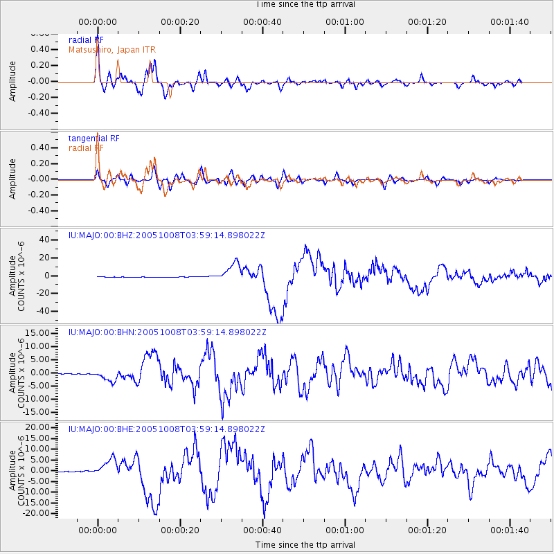
Signal To Noise
| Channel | StoN | STA | LTA |
| IU:MAJO:00:BHN:20051008T03:59:14.898022Z | 14.129379 | 2.2447778E-6 | 1.5887306E-7 |
| IU:MAJO:00:BHE:20051008T03:59:14.898022Z | 39.788177 | 4.339671E-6 | 1.0906936E-7 |
| IU:MAJO:00:BHZ:20051008T03:59:14.898022Z | 59.596092 | 1.1245108E-5 | 1.8868867E-7 |
| Arrivals |
| Ps | 4.6 SECOND |
| PpPs | 12 SECOND |
| PsPs/PpSs | 16 SECOND |


