You are here: Home > Network List > GS - US Geological Survey Networks Stations List
> Station OK031 2598 S. Brethren Rd., Cushing, OK, USA > Earthquake Result Viewer
OK031 2598 S. Brethren Rd., Cushing, OK, USA - Earthquake Result Viewer

| Earthquake location: |
South Of Fiji Islands |
| Earthquake latitude/longitude: |
-23.0/-176.3 |
| Earthquake time(UTC): |
2015/04/03 (093) 12:32:38 GMT |
| Earthquake Depth: |
59 km |
| Earthquake Magnitude: |
5.5 MWC, 5.5 MWC |
| Earthquake Catalog/Contributor: |
NEIC PDE/NEIC COMCAT |
|
| Network: |
GS US Geological Survey Networks |
| Station: |
OK031 2598 S. Brethren Rd., Cushing, OK, USA |
| Lat/Lon: |
35.95 N/96.84 W |
| Elevation: |
290 m |
|
| Distance: |
95.2 deg |
| Az: |
53.238 deg |
| Baz: |
245.466 deg |
| Ray Param: |
0.04080205 |
| Estimated Moho Depth: |
28.0 km |
| Estimated Crust Vp/Vs: |
1.88 |
| Assumed Crust Vp: |
6.426 km/s |
| Estimated Crust Vs: |
3.423 km/s |
| Estimated Crust Poisson's Ratio: |
0.30 |
|
| Radial Match: |
88.62629 % |
| Radial Bump: |
400 |
| Transverse Match: |
54.73458 % |
| Transverse Bump: |
344 |
| SOD ConfigId: |
872571 |
| Insert Time: |
2015-05-14 09:42:28.486 +0000 |
| GWidth: |
2.5 |
| Max Bumps: |
400 |
| Tol: |
0.001 |
|
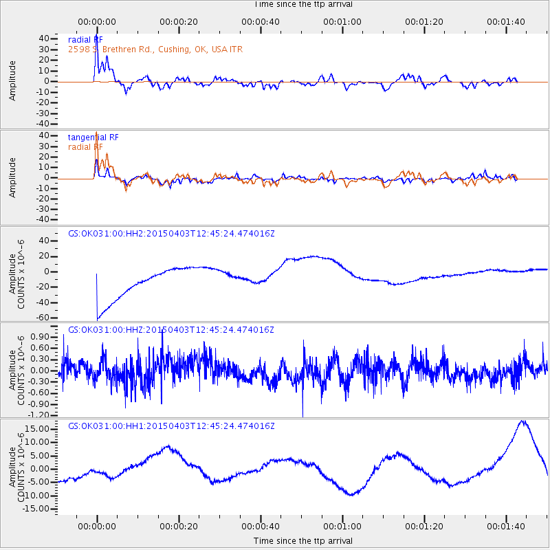
Signal To Noise
| Channel | StoN | STA | LTA |
| GS:OK031:00:HHZ:20150403T12:45:24.474016Z | 0.9266055 | 2.9950513E-7 | 3.232283E-7 |
| GS:OK031:00:HH1:20150403T12:45:24.474016Z | 2.1083996 | 3.6186536E-6 | 1.7163036E-6 |
| GS:OK031:00:HH2:20150403T12:45:24.474016Z | 0.6690889 | 1.3500387E-5 | 2.017727E-5 |
| Arrivals |
| Ps | 3.9 SECOND |
| PpPs | 12 SECOND |
| PsPs/PpSs | 16 SECOND |


