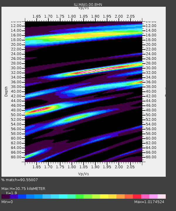
MAJO Matsushiro, Japan - Earthquake Result Viewer
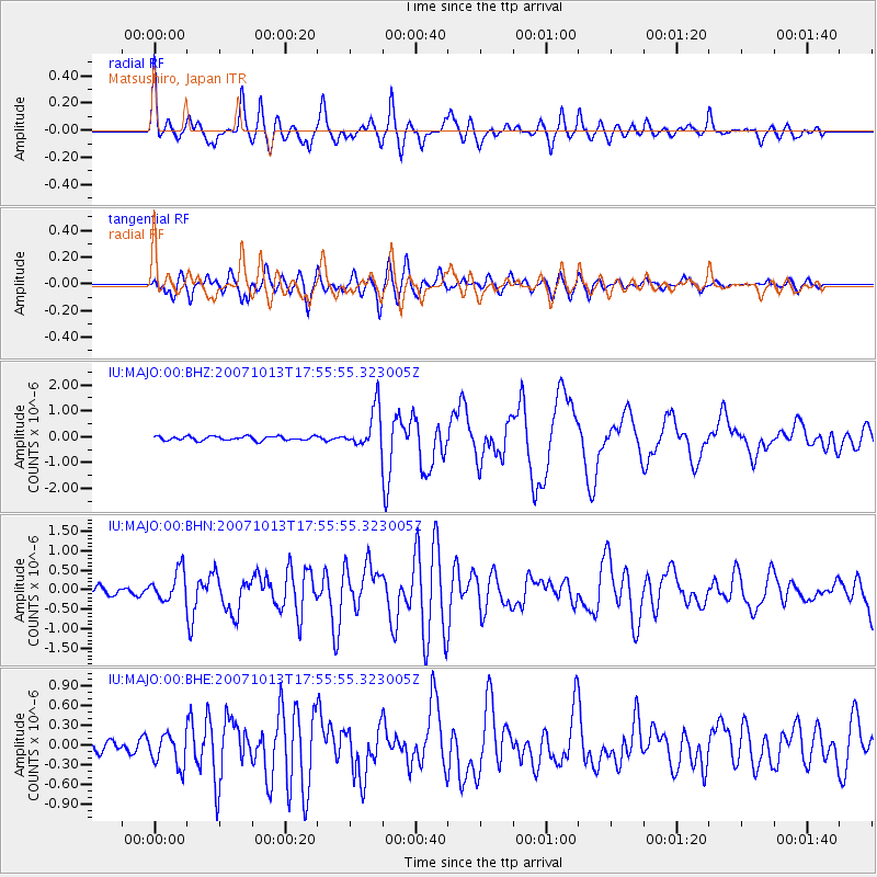
Earthquake location: Southeast Of Loyalty Islands
Earthquake latitude/longitude: -21.2/169.2
Earthquake time(UTC): 2007/10/13 (286) 17:45:53 GMT
Earthquake Depth: 37 km
Earthquake Magnitude: 5.8 MB, 5.9 MS, 6.1 MW, 6.1 MW
Earthquake Catalog/Contributor: WHDF/NEIC
Network: IU Global Seismograph Network (GSN - IRIS/USGS)
Station: MAJO Matsushiro, Japan
Lat/Lon: 36.54 N/138.21 E
Elevation: 405 m
Distance: 64.5 deg
Az: 332.651 deg
Baz: 147.844 deg
Ray Param: 0.058825456
Estimated Moho Depth: 30.75 km
Estimated Crust Vp/Vs: 1.90
Assumed Crust Vp: 6.461 km/s
Estimated Crust Vs: 3.401 km/s
Estimated Crust Poisson's Ratio: 0.31
Radial Match: 90.55807 %
Radial Bump: 400
Transverse Match: 84.8618 %
Transverse Bump: 400
SOD ConfigId: 2564
Insert Time: 2010-03-04 16:06:26.684 +0000
GWidth: 2.5
Max Bumps: 400
Tol: 0.001

Signal To Noise

ChannelStoNSTALTA
IU:MAJO:00:BHN:20071013T17:55:55.323005Z3.96837663.9363448E-79.919282E-8
IU:MAJO:00:BHE:20071013T17:55:55.323005Z2.8948472.4790657E-78.563719E-8
IU:MAJO:00:BHZ:20071013T17:55:55.323005Z9.8102997.785744E-77.936297E-8
Arrivals
Ps4.5 SECOND
PpPs13 SECOND
PsPs/PpSs18 SECOND